"There is nothing more pleasant than cruising on a boat with the whole family."
Letter from Empress Catherine the Great

Tuesday, February 28, 2012

Westing Along The South Coast of Puerto Rico


We anchored one night in Playa Salinas, five nights in Ponce, one off Isla Caja de Muertos (literally, Island of the Box of Death, but translated figuratively as Coffin Island) and two behind Islas Cana Gorda (which the Cruise Guide calls "Gilligan's Island.") So all told, nine nights since Vieques and 92 miles closer to home.
On a Sunday afternoon after a 49 mile sail from Vieques, Playa Salinas looked to us like a pleasant, friendly, sleepy little family-oriented vacation center for Puerto Ricans, located in a well protected cove. We regret that we did not give the town and its restaurants much of a chance to impress us; but most businesses were closed. The cove is entered from an “inland waterway” behind some barrier islets of rock and mangroves. We entered this waterway from the sea through an inlet named Boca del Inferno, but it was not scary, because we had furled sails to avoid having to make a pair of gybes under sail in the mouth.  After a few miles inside we came to the entrance to the Cove containing Salinas. The prevailing depth marked for the cove’s entrance was six feet but our fathometer did not show less than 6.5. 
Next day we sailed the 23 miles from Playa Salinas to Ponce, Puerto Rico’s second largest city (after the capital, San Juan) and a commercial port city.  We started by slanting out between some reefs but then the wind was too far directly behind us to sail directly for the mouth of Ponce Bay, so we kept a course a bit further off land to keep the wind at 150 degrees off the bow and rounded north to the port after passing south of Coffin Island. Coming upon that island from the east, it looks like two islands and it is only when you get closer that you can see that they are joined by a relatively low lying plain. 
Counting its low lying adjacent island it is more than a mile and a half long and is now a nature preserve which offers hikes. As seen from land (background below) it could look like an Egyptian mortuary with the head and body at one end and the feet sticking up at the other.
There is also a legend that a pirate buried his lady there in a coffin.
Ponce is located at the back of a bay that is about three miles wide and one mile deep which has a well marked shipping channel.  But unlike the great port cities in the US such as Neuva York, Boston, Baltimore and San Francisco, where the commercial waterfront is the edge where the water meets the city’s streets, the waterfront of Ponce is in a narrow inner bay at the eastern end of the big bay, quite remote from urban life. And the Ponce Yacht and Fishing Club, 

outside of which we anchored, is outside the commercial port, on (and sheltered by) a barrier island that has been joined to the mainland by a road and reinforced on its seaward side against the sea.  so the city is foreground, then the bay, then the big freighter in the commercial port and finally, in front of a row of trees, the YC.
Next is a view of the town in the background between two freighters taken from ILENE.

 Ponce YC is quite a nice large private club with halls for dominos, tennis, a swimming pool, a gym as well as showers, and a laundry room and fuel dock. It galls us a bit to pay for anchoring, which is supposed to be free, but the $10 per person per day gets you access to the showers, laundry and the dinghy dock.  Also, the office of the YC allowed us to sit in the office and use the WiF.


In the office we met Fafa, who owns a Freedom 30 and gave us a ride to the mall for shopping.


We also met Bob, here playing with Alphie,
a realtor from Sunapee NH, sailing “Brass Tacks,” a classy 2006 Caliber 40. 

Bob was waiting a few days for the arrival of his son from the west coast, who will help him sail Brass Tacks back to Florida to be sold.  We shared a meal with him aboard ILENE and he reciprocated the next night on his boat.  We shared taxicab rides to town, about $12 each way, and during one of them, Lene mentioned that we had also shared meals with two French-speaking ladies further south. He said: “Do you mean Manu and Michelle of Teepee?  I just hung with them, and their friend Marie helped me sail Brass Tacks up here from Antigua.”  And Bob also knows  John and Missy of “Tenacious”, who we had met in the marina of Spanishtown, Virgin Gorda.  So it is a small ocean out here after all.
One highlight of our visit to Ponce was Carnaval.
It is quite a big deal in the islands but we had never sought to time our visit to any given island to coincide with its Carnaval. Bur here we were and here it was, so we went and the loud Latin rock music was performed by "Ricky J and Swing," four very energetic and entertaining young men backed up by five variegated horns, three percussionists an electric bass and a keyboard. They did highly athletic synchronized dance moves behind and with the lead singer, a la mode Diana Ross and the Supremes, but on steroids. Like at the opera, before supertitles, I missed the humor in their banter but the audience standing in the city square didn’t miss it and were quite amused. Small groups of ghoulishly dressed werewolves, etc., wandered among the crowd. It was held in the central square, which by day houses not the courthouse, like at home, but the cathedral

and the firehouse museum (in Bergenfield N.J. High School's colors).
The square was lined with stands selling souvenirs and refreshments and bars were set up. That loud music of which I have been complaining was fun to watch and hear in this spectacular context. Regrettably I forgot to bring the camera but we were given a poster of the event.


\We spent another day visiting cultural and historical sites in the City. In the hills to the north of the city is the cross, built on the site of a former lookout tower. 
We got stuck, alone, in the glass sided elevator in the up position at the level of the arms of the cross for about ten minutes; the door would not open to admit us to the arms nor would the elevator go down. We were given bottles of water upon our release and toured the associated Japanese gardens
before the main event of the site - - a tour of the Museo Castillo Serrailles, (view from the cross)
a mansion, built during the depression for $40,000 by the family which makes Don Q rum. View from its gardens, below:

During the tour we met Al and Kathy from West Orange, NJ, who were on the island for a two week golfing vacation. They gave us a ride back down to town and after a mofongo lunch we visited the Ponce Museum of Art. It is quite an impressive building with a Lichtenstein sculpture out front.
It has a pretty good collection for a city this size, from the 1500’s to present, with a large number of famous European and North American artists. One piece that reminded me of home was by an American artist unknown to me, done in the 1880s:
"Rio Hackensack.”
Another day we rented a car with Bob to drive to the northeast corner of the island to climb in the El Yunque tropical rain forest. But the car  rental company got us a late start and it looked like rain was coming so after getting almost all the way to San Juan, we started to retrace our path on “Interstate” 52, and got off at Guavate, to partake of the famous pork served there at Lechonera El Mojito. Ilene had the fish.
After lunch we took Route 1 back to Ponce (think of Route 1 vs. I-95 in the northeast) and saw some beautiful mountain vistas and then did some provisioning.
The water in the small Yacht Club bay did not look really clean enough to use as the raw product for making fresh water and the watermaker demands special attention if not used to make water at least once per five days, so we left and decided to anchor in the lee of Coffin Island. We thought we would take the nature walks but the wind was strong and a beat, and by the time we had gone the six miles, which beating made ten miles, we were beat too and the wind continued to howl. We doused our reefed main and small jib and were sheltered by the island from the big seas, but the wind deterred us (and maybe in my case old age contributed as well) from dinking ashore to see the nature center. (This photo was taken days before, from the other -south- side with the mainland as background)
Next morning we ran back to Ponce, fueled up and sailed to what the folks here call Gilligan’s Island. It is actually an anchorage between Punta Jacinto, Punta Ballena, and Los Cayos de Cana Gorda. The last are three, closely situated little 
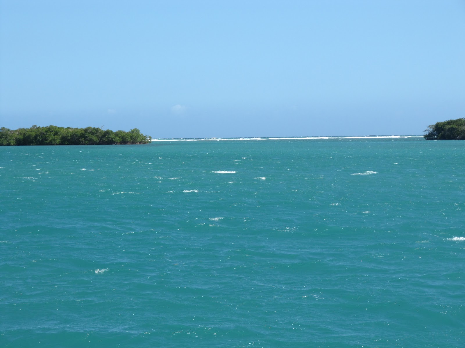
mangrove islands protected by a windward reef.  Here you can see the surf pounding on the reef through a gap between the Cayos, and that whitecaps have reformed behind the Cayos.

Again, no big waves got in but the wind was 30 knots when we were anchoring and continued almost until dark. Hence no touring of the beach on the Cayo or the town on Punta Jacinto. Next morning at sunrise, all was calm.

We dinked in to the town, which was actually a resort, the CopaMarina, and were greeted by Paul and Lindley of Bedford NY.

 He was a sailor for 40 years and they engaged us and offered us a ride to the town of Gaunica, about six miles away, so both couples could provision.  We had lunch with them in the hotel's outdoor restaurant while the refrigerables remained cold in the fridge in their room. Paul is also a photographer, www.paulthomassetphotography.com, so this next shot on the resort's dock, is a good photo.
We planned to visit the beach at Gilligan's Island, but the wind was ripping again in the afternoon so we just hung out, read, etc.
Posted from La Parguera, P.R.

Wednesday, February 22, 2012

The Spanish Virgins

Neither of us had ever before been to these islands, formerly called the Passage Islands, by boat or by air. They are small; Culebra has 3500 people and Vieques, 11,000. They are part of the “nation" of Puerto Rico, and that big island is what these islanders call the mainland.
Our passage from Great St. James off eastern St. Thomas, to Ensenada Honda (deep cove), Culebra, had very variable winds and hence a slow pace. Our course was west and the winds were from the east, but with variations.  They began from our starboard quarter and light, pushing us at about four knots. At one point, for five minutes they died absolutely before they came up on our starboard quarter, with resulting gybe. And they went back to starboard, and built to about ten knots relative, with periods of minutes at 18 knots. It was 23 miles and took five hours.
We passed this cruise ship, port to port; notice her bow wake, though she is slowing down to enter Charlotte Amelie.

We also passed Sail Rock, 120 feet high, in the middle of nowhere, which I remember from my navy days.
From 12 miles away, it looks like a sloop, but the human eye can focus in on things that the camera can’t capture, so we don’t have a picture of it from that range.
We anchored in Ensenada Honda, about 300 yards from the town’s dinghy docks, and
I went to look for US Customs to check in to Puerto Rico and it was a fifteen minute walk around the cove to the airport, where I waited about 15 minutes for the Customs officers to get back from what they were doing. They filled out the forms, on their computer based on my answers to their questions so I told them “Yes” about Alphie and Witty because I’m a terrible liar. As to their next question, about the cats’ papers, I said I could get them from the boat and that they were fully vetted, extremely healthy, and would not be leaving the boat. This satisfied them on that point. They asked about garbage and told me there is an authorized burning site about a ½ hour bus ride inland from one of the ports we plan to visit in Puerto Rico. I wondered, silently, how the other passengers on that bus would like it if we brought along large plastic bags of by then extremely old and smelly garbage.  They were very polite and explained the fear of importation of a bug that has infected mangos. I said we did not have any because they are not ripe yet. In the end, I accidentally left our passports on their desk and ten minutes later they drove up to me while I was walking back and gave them to me. They get high grades from me for courtesy and efficiency.
These islands have an interesting 20th century resulting from their use by the US Navy for target practice.  Here is a rusted tank on what the native’s call one of the ten most beautiful beaches in the Caribbean, Flamenco Beach:
And here is a tee shirt I bought, showing the tank and flamingos, flying in military formation over the beach:

The artist told me that the military had ruined Culebra but also “saved” it, because the existence of unexploded ordinance, while leaving the land safe for most uses, makes the island unsuitable for large scale building of high rise structures. There is a lot of resentment among the residents against the US.  Vieques’ weekly free 5” x 8” glossy tourist magazine has editorials detailing protest rallys and a spate of crimes.  
When we rounded the eastern tip of Vieques,
we noticed that it is uninhabited; and were later told that some folks are employed, at good pay, to locate and remove unexploded ordinance. So I'm not sure...maybe the ordinance protects against high rises?
We found a very substantial community of transported Norte Americanos, attracted by the laid back atmosphere, low cost of living (except for groceries) and climate. One of Culebra’s centers is the Public Library or as it is called there...Biblioteca Communidad,
supported by donations of books, computers, a coffee machine, and the labor of volunteers. Lauren, who lives on his 25 foot Cape Dory anchored in the Ensenada, rows to work in his dinghy to operate the library one day a week. He is quite knowledgeable about the collection, which is mostly English language books, but has small collections in several other languages. We used their wifi which is free to use and also donated.
Another such center of gathering of the gringos is the Friday morning produce market, all imported on a truck on the ferry from mainland Puerto Rico, with much variety and good quality. Because Luis will sell no veggies before his truck is fully unloaded, the waiting customers, including me, are enlisted as volunteer unloaders.
Here is beautiful and uncrowded Flamenco beach, with food kiosks in the middle (where I had another local beer, Meddalion), a resort ($110 per night for a double with kitchen) toward this end and a campground ($10 per night) toward the far end.
One has to go out about 40 yards to get chest deep with several one foot high sand ridges as you go out. No rocks and no shells, just pure yellow sand.
 There is a canal, suitable only for dinghys, which connects Ensenada Honda, near the docks, to the sea at the west side of the island. 
The land is less than ½ mile wide here, with the main ferry dock from Fajardo, PR at other, western, ocean side (but most of the fellow tourists we met at the beach had flown in for the day in tiny two or possibly four passenger airplanes that have to swoop dive to get to the tiny airport runway.) The one road over the canal is at the Bay side and has a lifting platform drawbridge, painted white and orange, which would still be too low for our mast if raised and which, we were told, had not been raised of 15 years. This is the view from the dinghy in the canal, with a few of the boats in the Ensenada visible under the bridge.
 Looking out the main entrance from the Ensenada to the Caribbean in the morning light.
We dined one night at Susie’s, on delicious, beautifully served food including mixed seafood cerviche and “island mash”: mashed potato, yucca, cassava and one other native island root starch.  The indoor part has the bar and several tables and the outdoor seating which we enjoyed, we realized next day, is the driveway of the gas station by day.
 Can you read the sign on this next store, so emblematic of the calm attitude here?
The people were very friendly and there are several other beaches and anchorages that we did not visit but after three nights it was time to move on to Vieques, sailing south to that island’s eastern tip on a gentle but fast port reach under sunny skies (“My favorite sail so far” said Ilene) and then west, a total of 24 miles. We had thought to stay in Ensenada Sun Bay, which looks like a big beautiful beach lined bay (think Orchard Beach in N.Y), but went a mile further and entered between Punta de Tierra and Cayo Real, off the little tourist town of Esperanza in 10 feet of water.  On this eastern side of its harbor, Puerto Real, we were one of two boats, while on the western side of the harbor, divided by a three foot deep sand bar, were about 15 cruising boats.  On the town's Embarcadero, we dined on Puerto Rican specialties (pastellilos of chicken, pork and conch, at La Nasa (the lobster trap) a roadside place where dinner for two cost $19.
There are also several places that look like they serve up a “fine dining” experience here as well, and gift shops, dive shops and a few of the island’s small hotels.
Then came our night time (no photos) wet kayaking tour on Puerto Mosquito, just east of Ensenada Sun Bay and not navigable (with only three feet of depth at its entrance). It is .3 x .6 miles in size and bioluminescent: having an extremely high concentration of light emitting tiny organisms. When you dip your paddle or hand in the water, they get startled and glow in the dark. Many fish swim in this bay and they too glow in the dark when disturbed, emitting zig zags of neon light as they swim away. We were one of four couples who took a ride in a van driven by Moses. He equipped us with life vests and paddles, led us into our “sit on top” kayaks, wore a red flashlight on the back of his head to guide us around the bay and told us about the bioluminescence and about some of the constellations and planets in the dark sky.  It was a spectacular vision, being a moonless night, and Moses pointed to the stars, planets and galaxies with his million watt flashlight as if it was a lazer on the planetarium ceiling and named many of them.  It was a great experience.
ILENE's anchor light, at the top of her mast, is lighted at dusk.
During the rather calm night there was a disturbing roll and we noticed that we had dragged about 100 feet so we picked up anchor, circled around Cayo Real, below, and anchored on its more popular western side, to the right.
The other disturbing feature of the night was not be solved by this ½ mile relocation:  When I asked the proprietor of La Nasa (He maintains an apartment four blocks from our house in New York where he lives 4 months a year) how late the music would last and expressed displeasure with his 2 AM answer, he and several other customers said with a smile: “This is Puerto Rico!” And the next night the music lasted until after 4 am!  But at least, the music was mostly tenors crooning romantic ballads accompanied by acoustic guitar, as compared to baritone DJs screaming guttural curse words accompanied by a back beat.
We visited Esperanza’s small archeological museum and Lene asked a woman who was driving to the island's capital, Isabel  Segundo, for a lift. She lives here seven months a year and near Denver in the summer. She dropped us about half a mile from the old Fortress. Its museum was regrettably closed but not its views of Puerto Rico in the background under the arch,
and Culebra behind Ilene, below.
There we met Ann and Ulla. Ann, with her husband, charter a 46 foot Beneteau, "Caribbean Lady" (anngmones@aol.com) Ulla operates amazingcharters.com, a business that matches people who would like to go on a charter vacation (with crew or bareboat) to available charterers. They gave us a tour of the capital area and dropped us at Coconuts for lunch. We made it to the big ferry dock in time to catch the incoming and hence a taxi waiting there for our trip back from Isabelle II to the boat at Esperanza.

Thursday, February 16, 2012

St. Thomas, USVI

We spent five nights on anchor in Charlotte Amelie harbor. View of the town, from the boat, by day,

and by night.

 Then we spent one more night on one of 23 free moorings, first come first served, in Christmas Cove on the west side of Great St. James island, 
about five miles east of Charlotte Amelie and one mile from Red Hook. 
We motored those five miles, not to avoid beating but because there was virtually no wind.  We snorkeled and due to a failure of communications about “which rocks” we were referring to, got separated. I panicked, raced back to the boat and got into the dinghy to search for Ilene, but she is a good swimmer and did not need help. She was impressed with the corals and saw a sea turtle. I saw a big ray, about 4 feet wide, swimming near the bottom, about 20 feet below us – the water was so clear.
I have been to St. Thomas several times in the past. My first visit was on the USS Hammerberg, DE1015. This was 1966 and we anchored out in the Harbor for about three days. I took the Law School Admissions Test aboard, administered by my superior officer, who the Educational Testing Service of Princeton NJ sent the test to keep in his safe, along with $25 (which was a lot more money then) and a stop watch. I mistakenly thought I had done terribly on the test and that night I got drunker than I have ever been, before or since, in some bar in Creek Alley (of The Momas and the Popas fame). Apparently, I am a happy drunk because instead of arresting me, the Shore Patrol carried me back to the launch which took me out to the Hammerberg. In subsequent years I attended a Bar Association meeting at a resort on the island, visited it as a passenger on cruise ships with by brother and sister in law and on various BVI charter trips to cab it between the airport and the ferry.
Though posted as reserved for Marina guests, those guest’s large boats are at its docks and have no need for the use of a dinghy in port.  I spotted “Knickerbocker” a magnificent yacht normally docked at the head of the Oyster Bay dock and reputedly owned by he owner of Madison Square Garden. So in reality, this dinghy dock is used by everyone except the Marina’s guests, including folks who live aboard their boats out in the harbor and work at the busy hub, parking their dinks at the dock eight hours a day, five days a week. This is the dock from which we said farewell to our guests and it is convenient to supermarkets, bakery, self service laundry and phone store.
Here is Lene at the other dock, at the seawall at the edge of the downtown area of the city, with part of the anchored fleet in the background.
We used this dock to get to a jewelry store in which Lene got emerald and diamond “huggie” style earrings for her birthday, a wifi bar, various lunches and the Synagogue.  For lunch we ate at local places. I had my first taste of "fungi" polenta with okra -- not bad, and the runner up was stewed oxtail.
The synagogue is one of the oldest in the western hemisphere, founded in 1796 and rebuilt in 1856, with sand floors and a Sephardic interior architecture. I had visited it in the past, but this had never been on a Friday night. Their prayer book is the same one we use at home. Services start at 6:30 and it is open to the public. The rabbi gave an excellent sermon against religious fundamentalist violence being a form of forbidden idolatry. The congregation of about 30 people in attendance,was  1/6th black. The post-service “oneg” (literally “delight” actually refreshments) included olives and herring in addition to wine, challah and cheese.
One day we took the bus to Redhook, a sailing center at the eastern end of the island. The fare was $2.00 per person each way. We got a new reefing line to replace the one that had chafed through again, and I taped a thumb lock out of the way, hoping that this lock is the culprit that has been eating reefing lines. We also got a chart book for the Dominican Republic.  I had thought that this was the last chart book we would need and that the two for the southern Bahamas and  northern Bahamas, since they overlapped, eliminated the need for the book for the central Bahamas. But no, while A overlaps a bit of C, only B has the detailed views of the ports and anchorages of the Exumas and Eluthera, so we still have one more chart book to buy.
On the bus we met Cathy, who suggested we visit Hassel Island, by dink, but wear stout shoes for the thorns.
Here is Lene at Careening Cove, 

where we visited an enchanted sail loft which does not advertise because “I have too much business already”. The island is about .2 miles wide by .8 miles long, oriented generally north to south, and divides Charlotte Amelie Harbor into two halves as Prudence Island divides Narragansett Bay into western and eastern passages. But the thorn filled path to the various British fortifications of the early 19th century, when the British briefly occupied St. Thomas, were approachable only from a new and rugged dinghy dock further south. The VI National Park service maintains the trail and its sights. First the storehouse:

Then, a bit higher and most seaward, the Prince Frederick’s Battery, renamed Fort Willoughby during the occupation of St. Thomas by the Brits in the early 19th century:
 And finally, a view of the anchorage and Charlotte Amelie from Cowell’s Battery, at the summit, 267 feet above sea level. Its guns, when they were there, commanded both the east and west entrances to the Harbor.
 The battery later served as a signal tower so warehouse operators in port could gather their stevedores when a vessel was sighted approaching the port. Radio obviated the need for such a tower. We were the only dinghy and only people to visit during the time we were there. Here is a view of all three military sites and the steep path to the top one, taken from ILENE when we were exiting the harbor.
One morning we awoke to see a black freighter at the far end of the cruise ship dock. And it looked like it had more crew than a freighter would need. And it was called  "Kennedy" and flew an American flag.
 What could this be? I went over and asked. She is the Mass Maritime Academy training ship with 700 students aboard, far from her home at the eastern end of Buzzards Bay, the southwestern entrance to the Cape Cod Canal.
One beef about St. Thomas: the authorities have apparently permitted someone to operate some sort of outdoor venue with a DJ screaming his “lyrics” along with his “music” at megadecibel levels on Saturday and Sunday evenings and well into the following mornings, thereby disturbing the peace and tranquility and sleep of the entire town.
From Great  St. James our plan is to continue our westward migration from the US Virgins to the Spanish Virgins, Culebra and Vieques, formerly known as the Passage Islands. From here on until we get to Virginia, we will be visiting only new ports -- hardly uncharted, but new to us as sailors. We have plotted out our route and time, with five extra lay days and five additional potential weather delay days between February 14 and March 14 to traverse the waters between Great St. James and Grand Turk Island in the Turks and Caicos, when and where we plan to pick up our next guests, two lovely ladies from Portland who were Lene’s friends and now are our friends.  This month includes four long passages between 75 and 115 miles, so we have also built in rest days for the days after each of these passages as well. Lene is worried about these passages, especially the dreaded Mona Passage, but we will be heading west, the easy direction, and will wait for good weather windows.
Posted from Bahia Honda, Culebra, Puerto Rico.