"There is nothing more pleasant than cruising on a boat with the whole family."
Letter from Empress Catherine the Great

Saturday, May 26, 2012

Charleson, South Carolina


We arrived here late in the afternoon of Wednesday, May 16, and left at 6:30 am the following Wednesday. Our first two days here were enjoyed in getting to know our new friends, the ones of “Autumn Borne” who had helped us here on our way from Beaufort, Dean and Susan. See autumnborne.blogspot.com.
They have lived aboard for about five years on their CSY 44. They keep her in the Hudson, near Albany, to be close to family, during the summers. Dean is a Vietnam Vet who did heavy combat duty there, and thus hates war, a musician and a mechanical engineer with a lot of experience in engineering big projects. Susan did IT for a College up in Buffalo. They have been bikers and done a lot of things in their 42 year marriage, so far.They are fun people to be with.
They anchored in the Ashley River near the big marina there and we docked at the Charleston Maritime Center in the Cooper River.  ILENE is almost hidden behind the big schooner next to it but recognizable only by her double head stay. The marina office is on second floor of white building background right. Aquarium, Ft. Sumter ferry and Patriot Point ferry are all off to the right.
A manatee swam under our dock:


The city is the peninsula of land at the confluence of the Ashley and Cooper Rivers, bearing the first and last names of an early local hero. Its tip, called The Battery, is like the Battery in Manhattan, except this battery has cannons.

The city has since expanded north and onto the opposite shores of the rivers.  The street connecting our two locations is, what else, Calhoon St. Dean and Susan walked its length over to us for mango pancakes our first day here and stayed through lunch, meanwhile helping me fix the fuel problem we had had during the trip. We agreed to go to the movies the next day and walked to their marina and cabbed to the movies to see “Salmon Fishing in The Yemen” which was charming, and “The Dictator” which was coarse, crude and puerile, except for a great speech at the end.
We did a day of cleaning and blogging and then on to sightseeing. There is an expensive ferry to take folks to Fort Sumter.


The fort is run by the National Park Service and admission is free, with an excellent NPS docent.  


It has a museum relating to the causes of the Civil War at the City end of the ferry landing, and another in the fort dealing with military aspects. The fort was built on an underwater shoal, by dumping lots of stone on that shoal.
It was built, one of 42 such forts, erected in the aftermath of the War of 1812, when our cities has been bombarded by the British. It is a small portion of its former self, that portion having been preserved by the debris falling onto it in the process of the North’s seige and bombarding it when retaking it late in the war. The first shots were fired after the northern commander had refused a demand for surrender. He surrendered only after the wooden structures were set afire, threatening the magazine and his reinforcement ship had turned back when fired upon while approaching. He and his men were permitted to lower and take their flag with them and were sent back to New York rather than taken as prisoners of war. When the North retook the fort, there was no surrender, just a withdrawal by the south.


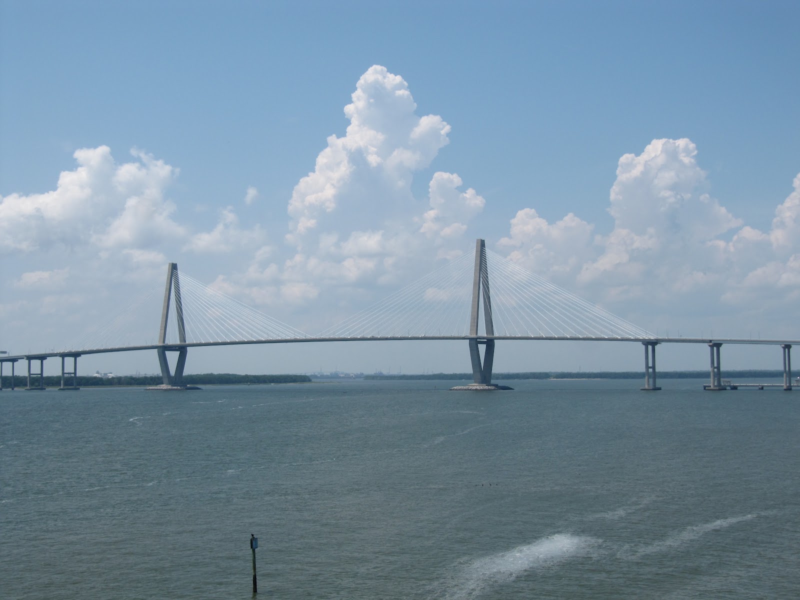
The bridge across the Cooper River is quite beautiful, don’t you think?
The aircraft carrier Yorktown CV-10 and  the destroyer Laffey  DD-724


both served in WWII and are now at Patriots Point, across the river. 


Lene in the destroyer's Captain's chair and by the catapult on the carrier's flight deck; Roger in a sort of Dukakis moment.


They have a Congressional Medal of Honor hall of fame on part of the carrier’s hanger deck, where I looked up Owen Hammerberg, who, having saved one shipmate, died while trying to save another. The destroyer escort on which I served, was named after him.


We visited the Old Exchange Building
Used as a dungeon for pirates by the colonials and for supporters of our Revolution by the British, our Docent was obviously enjoying his explanation of it.


The ballroom upstairs is where President Washington was feted, the secession was signed, and public functions and weddings are held these days. The first crop that made South Carolina rich, with nine of the ten richest people in the colonies living in this state, was not cotton but "Carolina Gold" namely rice, traded here. Facade of a rice warehouse, by the docks; the rest blown away by a hurricane.


St. Michael’s steeple was painted black in war time. It towers over this essentially low rise city and many famous residents of this state are buried here.
 The Gibbes Museum of Art
has a mediocre permanent collection trying to show the history of the City through art, heavy in portraits. It also had a beautiful temporary show of large watercolors of southern working people doing jobs that are going away: shrimper, mill worker, tobacco farmer, drive in movie operator, elevator operator, shoe shiner, etc.

I visited the historic Edmondston-Alston House, right next to the seawall that protects the city from the sea, with steps down to the street and an artist seated on the wall painting the house:


It is one of many old luxury homes lining the Battery.


Magnolias in bloom from the Edmonston-Alston house's porch:


I walked around the oldest part of town, near the battery, where very old homes, registered as historic, are being lived in and sold at very expensive prices, with plaques showing their history.
The battery’s promenade is not a boardwalk, to let waves pass under, but a seawall, to keep the sea out of the city.
From the Battery: views of the Cooper,


 and the Ashley, with Battery Park at right,


and the park's monument to confederate soldiers.
Posted from River Dunes Marina, Oriental, N. Car.


Monday, May 21, 2012

Beautiful Beaufort, Soth Carolina


The “Beau” in Beaufort SC sounds like those same letters in “beautiful; this contrasts with the sound of those same letters in Beaufort NC, which is pronounced like “bow” in bow and arrow. But if you mispronounce their city, the residents, very friendly, will patiently just correct you. Beaufort, population 12,000, in the 2010 census, according to the reference librarian at the county library,
is the county seat of Beaufort County, population 162,000, most of them being on Hilton Head, which is in the same county and has vastly surpassed the historic town.


We spent and enjoyed two nights and one full day here, at the Downtown Marina (ILENE toward the left).
It is a small marina, friendly and efficient, operated by the municipality. Its only problem is a strong current running up and down the Beaufort River. They put us on the outside dock but close to boats in front and behind us. Ilene brought us to the dock skillfully, letting the wind blow us on, and we used a springline to get our bow away from the dock and from the stern of the boat in front of us, in departing. The marina provided free wifi, that works, but I went to a nearby coffee shop to get a super strong signal for uploading the photos for the Savannah posting.
They call it the Downtown Marina because it is one short block, through a lovely municipal park from the main drag:  Lene, here on one of about 20 municipal swinging benches facing the sea and the men's afternoon lawn bowling league (or is it Bocci?) with the chains of one of those swings in the background:


\


Bay Street is the main street in town, with lots of restaurants, art galleries and other shops.We had good food in Plums for lunch and Saltus for a more "fine dining" dinner, a rare two meals off the boat for us in one day. We enjoyed the local shrimp, mussels, scallops, clams and oysters in addition to swordfish.


 We took a guided tour of town with Buck, and his mistress:


 Buck knows the way, which is why the driver spent so much time facing back and narrating.


We saw lovely old homes


How do you like these Spanish moss laden live oak trees?


This is a large bowl made of a hollow limb of a dead live oak, open at both ends. I was very tempted to purchase it ($200) because of its natural beauty; but where would we keep it.


The bricks in this wall were used as ballast in British ships and then repurposed once the ships were on this side of the puddle.


We passed the first Black Church in town, with a bust of Robert Smalls, a native son who escaped slavery during the civil war by commandeering the confederate ship on which he had been working and was later elected to Congress, and we saw the local Synagogue


Altogether a very pretty little town. Lene said: “I could live here.” But I don’t think so.

Saturday, May 19, 2012

Two Days on the S. Car. Inter Coastal Waterway


Having sailed out in the ocean from Fort Lauderdale to St. Augustine and from there to Savannah, our next two hops, from Savannah to Beaufort SC and from there to Charleston SC were in the Inter Coastal Waterway ICW) called "the ditch". Our distances were 43 and 59 nautical miles on the two days.  Here, waves are not a big concern and winds are normally light but the path is twisty, so this is mostly a motor propelled journey. however, we did set the little jib for a bit more propulsion and even sailed the last ten miles to Beaufort SC on a favorable current up the Beaufort River. Sailing in the ocean, auto pilot steers us to our destination for hours, with occasional checking and minor adjustments of one degree to port or to starboard if ILENE drifts off a bit. Here, however, there are buoys or day markers (buoy signs on stakes) every few hundred yards requiring the helmsperson to pay attention to the charts, the GPS and what his or her eyes are saying, to keep on a course with numerous bends of up to 90 degrees.
There are a variety of conditions as to depth and width in the ICW. While average depth in this stretch was an estimated 15 feet, we experienced 30 feet or more in some places, and the scary sound of our depth alarm screaming at us that we had less than seven feet (16 inches under our keel) in some stretches and once less than six feet. Some of the Sounds we traversed were a mile wide with sufficient depth through most of their width. Others are just as wide but have a deep enough channel cut through them that is quite narrow. Here we are following another boat and it looks like there’s nothing but room. But if you notice the red triangle on the post, you can see that we have to pick our way from pillar to post to stay in the deep channel.
A shrimp boat overtaking us:


Our vigilant lookouts enjoying a calm passage:


We passed big homes with long piers leading out to their pavilions and floating docks.


We meant to take a photo while passing Hilton Head of the beautiful circular marina with the red and white lighthouse that my brother likes to visit, by land, but while passing we were overtaken by a strong rainstorm that obliterated visibility. But we did photograph a less picturesque Hilton Head Marina.


Daily distance to be made is relatively easy to compute because the charts have magenta lines, perpendicular to the twisting track of the ICW, at intervals of every five statutory miles. So with Beaufort at statutory mile 536 (one away from 535 by extrapolation) and Charleston at 467, the difference is 69 statutory miles. But our speed is in knots, meaning nautical miles per hour, and a statutory (land) mile of 5280 feet is .88 of a nautical mile of 6000 feet. I round this 88 percent to 90 percent so I just subtract ten percent, reducing the 69 statutory miles, by let’s say 7, to 62 nautical miles. This means that with let’s say 14 hours of daylight, if we leave at 6:30 am, we will get to our destination by 8:30 pm nightfall even if we only maintain an average speed of only 4.5 knots. The first day was easy and, as mentioned, we actually sailed a bit and got in at about 4 pm. The second day was longer.
Speed is very dependent on tides, bridges, depth and unexpected circumstances.  In shallow water we go slow. As to tides, the ICW in South Carolina uses rivers and sounds that run from the land to the sea, with canals cut through between them from one to another in strategic places to shorten the course.  If you get a favorable tide ebbing out to sea on one river that you are following toward the sea, that tidal flow will be continuing in the same direction for six hours in the next river, where you may be motoring upstream against the tide and current. And only persons with excellent knowledge of the local waters will know which way the tide will be flowing in the man-made canals between the rivers. We sought to motor at six knots, and actually made as much as 7.8 knots over the ground with the tide and as little as 4.2 when against it.
Most bridges we encountered were the modern ones, with the bottom of the span in the center being 65 feet above the water level at the normal high tide, sufficient for us to pass under at any time because the top of our mast is only 63.5 feet above the waterline. Such high bridges are expensive to build, but low expense because bridge tenders need not be hired. They have signs with numbers posted at the footings of the bridges which show the exact number of feet from the level of the water showing against the sign at the time of your passage, let’s say 68 feet at low tide and as little as 62 feet at extreme highs caused by full or new moons and flooding.
But there are also lower bridges that have to be opened by their tenders.  Some open on demand and others, only at fixed times. We had a problem with one of these, located only a few miles before Charleston, caused when our engine stopped for a few minutes.  We burned a lot more fuel per hour than I had realized while going full tilt, as we had coming to Savannah, than at idle speed with no load as when chilling the refrigerator. Our aft fuel tank had run dry.  It took me a few minutes before we could get it started again using the other, forward fuel tank, which was full.  On the day of that stoppage we had followed a boat called “Autumn Borne”, with a hailing port of Buffalo, NY, through the bridge at Beaufort, SC, at its 7:30 am opening.  I had asked Lene to call them to strike up a short conversation about where that they were going. They said that they were headed for Charleston, as we were that day, had done this trip many times, and offered to let us follow them, which we gratefully accepted.  In fact, the first photo in this posting shows them ahead of us. We had the small head sail up, more for stability than speed, when the engine stopped. We still had one knot of propulsion and we called them to tell them that we would be dropping back and would catch up with them at Charleston. But they, as I would have done, returned to provide help if needed, though they did not even know our names yet. It is a beautiful thing that sailors look out for each other. 
A few minutes after our engine came back to life, they told us that the low bridge near Charleston had no openings from 4 pm to 6:30 pm - rush hour for the land people.  I confirmed this, and doing the math, later reported that if we could maintain six knots, for the remaining three hours until 4 pm, we would be OK.  Autumn Borne concurred. We were actually going faster than six knots until we came to the cut over which the problem bridge crossed. Then we hit the strongest adverse tide of all. Even running the engine at full speed, we were slowed to 4.2 knots for about a mile. When the bridge came into view, we saw that it was already open to permit a big dredging rig to pass. We hurried and made it under that bridge with 13 minutes to spare. Whew!
We will soon report on Beaufort and on Charleston, but the next leg on the ICW has a notoriously shallow stretch and so we hope for weather that will permit us to sail in the ocean.
Posted from Charleston, SC.