"There is nothing more pleasant than cruising on a boat with the whole family."
Letter from Empress Catherine the Great

Monday, April 16, 2012

Eight Nights at George Town


We arrived in George Town on March 28 and left after eight nights, on April 5. G Town is the capital of the Exumas. For the first half of our stay we anchored in Elizabeth Harbor, on its side further from town, where we were sheltered by Stocking Island from the strong easterlies, off what is known as Sand Dollar Beach. We saw, upon arrival in strong winds, that almost everyone else was anchored on that side, about a mile from town, and we followed the wisdom of the crowd. Elizabeth Harbor could have been called Stocking Island Sound, just as Long Island Sound is the body that separates Long Island from the mainland. Stocking Island is about five miles long and lies parallel to the coast of mainland Great Exuma, making Elizabeth harbor about five miles by one mile. But there are many large impassable shoals in it and it never gets more than twenty feet deep. But there is lots of room for big scope on one’s anchor and lots of room between boats. View from Stocking Island with anchorage in foreground and G Town behind.


Downtown is a group of businesses that line both sides of a street about half a mile long including two banks, Immigration, two food markets, several souvenir shops a government center including the Post Office, a small Yacht Club, Customs, two small hotels, three places that sell electronics stuff or services, a Bahamas Telephone Co. (Batelco) office which was closed for renovations, a laundry/laundromat, several bars and snack bars, a gas station, two places that sell boating supplies, etc. Some are in modern two story buildings while others are in well, shacks. The road is one way through town and crosses a stone bridge over the inlet to Lake Victoria, which is about .1 by .2 miles and which has the dinghy dock that provides access to town from the water. View from the bridge of Lake Victoria including dinghy dock and sign on path from dock to town:


On the outside of the bridge is Kidd’s Cove,
a small cove near which we anchored for the second half of our stay, after we got our lap top charger cord, when we had more “town” things to do, i.e., the internet, laundry, ice, groceries, jerry cans of diesel, propane, souvenirs, etc.

  Our first stop ashore was at the bank to get ATM dollars, and then spending some of them to wire money from that bank to the bank of the vendor in Nassau of the lap top charger cord, which would not accept Amex or any other credit card; welcome back to the mid 20th century! 
Then to Customs and, at the other end of town, Immigration. I had been worried about being asked questions about where we had stopped during the six days and 250 miles between Provo and G Town.  But the earnest and polite young man behind the counter was only interested in my filling out his three forms (two more forms at Immigration) fully and accurately, in triplicate or duplicate, inserting the carbon papers correctly between the forms, and, oh yes, collecting the $300 fee, and filling out his three other forms that were given to us as receipts. The good news is that we do not need to check out from the Bahamas, but instead, can conveniently mail the permit back to Nassau from Florida.
There are a lot of boats in G Town, as many as 450, we were told, though less when we were there, past the peak in their season. Many come from the US and Canada and go no further, spending months here in the harbor, away from the cold north. We missed the event of the season, the National Family Island Regatta, in which the Bahamians race their traditional wooden sloops in the harbor and many parties are held. Here is the viewing bleachers and committee stand.

They have a daily morning weather report and net on the VHF radio. When arrivals were solicited by the controller, we announced ourselves and I asked if anyone had a chart book for the Exumas and offered to trade for charts of points further south.  I had used a series of sketch chartlets in our cruising guide to familiarize myself with the route into the southern end of the harbor through the shoals and then used the chart plotter to get us through, but a real chart is best. Boomerang, a 34’ Hunter with Mitch and Jessica from Vermont answered, and we switched to another channel, set up a meeting and spent several pleasurable and productive hours on their boat that afternoon while repairs to their dinghy were drying. We parted with their Exumas (central Bahamas) chart book and $100 and they kept our three chart books for the Dominican Republic to the Spanish Virgins, to the Windward Islands and to the Leeward Islands (Anguila to Grenada). They also told Lene about iNavX which provides charts of the whole US east coast on the iPad and uses its GPS feature and a navigation program to permit navigation and a cool anchor alarm that can ring in your bed, where you will hear it,  rather than out in the cockpit. A good backup which Ilene bought and Jessica trained me how to use.
Highlights of our stay:
A Cruiser Appreciation Tea at the Palm Bay resort about two miles away, that we visited by dink, sponsored by the Ministry of Tourism. The Tea was announced on the Net. They provided a “Rake and Scrape” band to entertain with standard calypso music. Rake and scrape apparently means that in addition to a guitar and several hand beaten drums there is a player who scrapes a screw driver blade along the teeth of a hand held rip saw.
They also presented a fashion show.
And many delicious native foods and a chance to meet other cruisers.  And the price was right too: Free!
Another day, a “Bonfire on Sand Dollar Beach” was announced on the morning Net. Several calls got us the particular spot on the beach, the time, and what foods/drinks to bring. It was very close to where we were anchored. About 30 folks showed up. We brought manchego y  membrillo, but not having manchego cheese on which to base the guava paste, we used what the store labeled as provolone, as a substitute hard-salty cheese. But it was not a successful dish, though the pieces were all eaten, because the alleged provolone had the flavor and consistency of muenster. And, despite bug spray, the sand flies were vicious and we retreated from the beach after about 40 minutes. The morning after the fire:


We visited the heart of the cruiser community at volley ball beach, about a mile away on Stocking island. We did not partake of the roast pig at the Chat and Chill,

the landmark eatery on that beach, largely because we forgot to bring money.

Lene met folks who operate a luncheonette and motel in the touristy lake section of Michigan in the summer. I got into a volley ball game.
We walked across Stocking Island to see the other side – it is high and narrow. And we saw the lovely eroded rocks of this place, the type of rocks that the Japanese love to install in their contemplative gardens.
On the mainland, we had two great lunches at Peace and Plenty, a nice restaurant in a hotel and got some souvenirs.
I almost led a Passover Seder for a black congregation. While dropping off our propane canister to be refilled, Naamen Forbes, the enterprising and polite propreiter of that and other businesses informed me that a rabbi had arranged with his minister to lead a model Passover Seder for his black congregation, but had fallen ill. I volunteered to do it and for a few hours was thinking how I would do this. Their religion forbids alcohol. No problem; “the fruit of the vine” which we bless includes unfermented grape juice. I have no matzoh, kosher for Passover or otherwise. No problem; we can use those small round Carr’s crackers as a symbolic representation of a matzoh. I also have no Hagaddah, the book with the service written in it aboard. No problem, after more than sixty of these seders, I know it well enough to give them the important elements without the book. But I’m a layman, not a Rabbi. No problem, this particular ceremony is normally performed at home without clergy.  I was all wrapped up in planning this until I checked back a couple of hours later. Naamen’s minister concluded that having called the program off, it was too difficult to get it back on the tracks that night, which was our last in G Town.
We fixed a few things for the boat. The flag halyard for flying the Bahamian courtesy flag came off, permitting Lene to haul me up to the lower spreader to reinsert its line in its block there. I replaced both screens in the port café door, that the cats had clawed through, but this was disappointing because they have clawed through one of the new ones already. A tear in the sheet we use as a slipcover on the starboard settee was repaired with adhesive thin sail tape on the back side, reinforced with stitching. Not much work done; I'm getting lazy. We planned routes and distances for about a half a dozen cool spots up the Exuma chain, which will be the subject of the next posting.
Here is a Still Life with Fruit and Cat, with lighting that came out in the Dutch Masters style, I rather think:
Posted at

Friday, April 13, 2012

Slogging Through the Lower Bahamas

These lower Bahamas  from Turks and Caicos to George Town, are not tourist destinations except for people who really want to get away from it all.  They are conveniently located stepping stones between the mid and upper Bahamas and the Virgins or Puerto Rico. We made six passages in seven days, aggregating 248 miles.
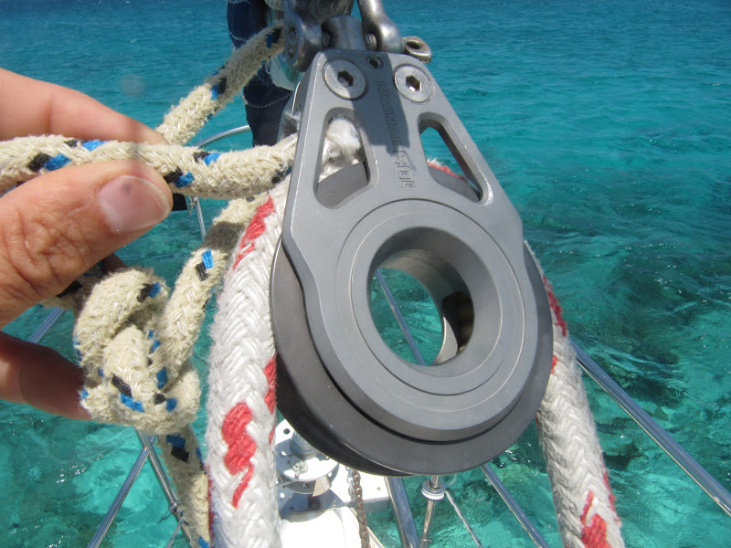
On the first day out I caused us a bit of excitement by my stupidity. I had put up the small jib before we cleared the Sandbore Channel, out of the west end of Providenciales and the Turks and Caicos, to aid the engine. And I used the thin yellow lines that I had tied to the clew of that sail and run to blocks on the toe rail and then aft, to pull the aft lower corner of that sail downward and outward more than the sheet on the car on the cross-boat track allows.

Good idea (from another Saga owner) for getting more performance out of that small foresail when the wind is aft of the beam. But when it was time to hoist the main sail, which requires Lene to steer straight into the wind, this thin yellow line was left unattended and loose. It somehow flogged a bend of itself (two thicknesses) into the block, between the sheave (the wheel itself) and its housing, jamming that block. As a result, I could neither ease the sail out nor trim it in; and more problematically, I would not be able to furl the sail at the end of the day. So what to do? Donning life preserver and harness and clipping onto the jack line, I went forward with knife and ice pick and cut the last foot or so of the line, used the ice pick to pick out fibers from the log jam and cut the loose fibers off. I asked Lene to tension the sheet so that if and when the jam gave way, the sail would not jerk out and pull me overboard. We were heeled at about 35 degrees and water was splashing over the bow, cooling me off. After about a half an hour, it worked.  Hence plan B, to lower the sail on the bouncing foredeck and gather it together so it did not wash overboard, was not needed.
The 47 miles went by quickly. From noon to 4:30 the half hourly readings showed we made a steady 8 knots. But the destination, Abrahams Bay, in the SW corner of Mayaguana, is coral head strewn and the outside reef stops the big waves but not the wind. We entered the Bay through its safer, wider western entrance, but this left us anchored five miles from town, where we were supposed to check into Bahamian Customs. A ten mile round trip dinghy ride that evening was not going to happen. Instead, we became illegal aliens in the Bahamas from Mayaguana until George Town, except that we did not step ashore but once.
Next morning’s excitement came when the GPS couldn’t get a fix. All of its other chartplotter functions in showing us our direction, speed and many other things depend on its knowing where it is. What to do?  I went into the pieces in the lazarette where the antenna connects, like I had watched Herve, Grenada Marine’s electrician do, but the best I can say for these efforts was that I was able to put things back together again.  Plan B again:  We have two very old hand held GPS devices. These do not have chartplotter functions, but if they work, slowly, using lots of AA batteries and working from only three rather than 12 satellites, they give you a fairly accurate digital display of your latitude and longitude so you can find yourself on the chart. So we filled them with fresh batteries but first of them would not start at all, no way. So remove the fresh batteries and put the dead unit in the garbage. The second unit, to the left of its more powerful big brother in the photo, took a long time, but came to life at last, and eventually got a fix!  

Well they always act slowly at first, especially when you start them at a great distance from where they were last turned off, which it this case had been Long Island Sound. I think they are checking their internal logic saying “They can’t be that far away, can they?” Next step was to put in waypoints, the place where you want to go, so the toy can tell you the direction to steer to get there. I used to know how to do this, but we haven’t used this unit for at least ten years so there was a new learning curve. Half way through climbing this curve, the boat’s chart plotter got its fix. So we were off.

Soon after, we learned that Avatrice had incurred a much more serious problem than we: failure of her transmission. The sails are great for the open waters but in narrow twisted channels through reefs, you want your engine. I was able to give them, from our cruising guide, via VHF, the names and phone numbers of some diesel repair guys on the islands we would be passing and suggested they call in to The Coconut Telegraph, a SSB network. Later, we heard a call on a different net for any sailors to please give them assistance. We have not heard from them since then but hope to connect with them later on their trip to Maine. 
At the end of this day we anchored off West Plano Key and bought a nice sized Grouper from three boys in a rowboat with an outboard, who cleaned it and, at our request, brought half of it to “Tamera Sue.” $20. The boys said they were from the Dominican Republic and worked (sunup to sundown  seven days a week, no doubt) from a “mother ship” which was anchored about three miles away, where they lived. This was a six week trip for them. West Plano Cay is a beach.
Then it was the 50 miles to Landrail Point, on Crooked Island. Wind too light and behind us so a motor sail, mostly motor, to another beach. But it has a pretty lighthouse, don’t you think?
Next day it was 40 miles to Clarencetown on the southern end of Long Island. Here we took our only lay day of the week and went ashore. This sign:
says it all, except it says more than it all, because the “historic sites” are the churches, and its post office and police are the government complex, and the restaurants are two in number, only one worthy of the name. At Rowdy Boys we had lunch and devoured their wifi via the iPad. Here is the town, home to about 200 of the 3000 folks who live on the island, taken from the Church steps, Lene lying on the wall lower right, ILENE, anchored behind the trees to the right.
The two churches are vaguely similar and interesting. The first, built by an Anglican missionary, recently had part of its roof blown off in a hurricane.   
The second, built by the same man after he had converted to the Roman Catholic faith, has an even more commanding presence, on a higher hill but it too has suffered damage: the cross on the right steeple is missing.
Friendly people. Some boats stop here at night—generally after sailing northwest, with the prevailing winds behind them, like us. Others leave in the evening to sail at night, when the winds are lighter – generally those heading SE, into the wind.
Next the length of Long Island, along its SE coast, from Clarencetown to Calabash Bay, 49 miles. On this trip, I miscalculated our time of departure and did not figure on an adverse tidal flow, or that it was a beat. So we had to motor sail a good part of the way in order to make sure we got into Calabash Bay, past the unmarked invisible but charted reefs, well before dark. Another beach on another blowy night.
 And finally the 24 miles on broad reaches, from Calabash Bay to George Town, Great Exuma Island, where we had fun. The subject of the next post.

Posted from Warderick Wells, Sea Land Park, Exumas, Bahamas


Wednesday, April 4, 2012

Judy and Meridel and Turks and Caicos - Part II


We spent five nights and four days in Southside Marina, the "land" part of our time in T&C.
Three of the days were with Meridel and Judy, who flew out the last day. They took a room in a hotel at the larger and more commercial but equally tricky-to-navigate-through-the-reefs-to-enter Turtle Cove Marina on the north side of Provo. Below: three beauties, and you can see part of their marina reflected on the window to the right.

 They wined and dined us with dinners in elegant restaurants on the beach such as this one.

And, oh yes, they let us shower in their hotel room under hot water, lots of hot water. (Most non-classy restaurants have only cold water in their sinks and the marina’s shower is of that flavor as well.)
I can’t quite get over how developed and hence different this island is from most, especially from other islands of this nation, like Grand Turk. The others have a tourism industry but it is small and low key. We should have been tipped off about Provo by the volume of the passenger jets we saw taking off from the airport while we were sailing there from French Cay. Most of the tourists are from the US and Canada. We even heard a rumor that the Canadians, being a British nation (well except for Quebec) put out a bid to buy the whole nation a few years ago. The rumor may even be true! The north shore is a huge long beach, protected by a reef, with hotels, clubs, condos and private residences cheek by jowl almost its entire length. This is mostly luxury type housing with lots of private security guards, because it only takes one violent incident to kill the goose that feeds the entire tourism-based economy of the island. The difference between this and Florida is scale and that here there are no buildings higher than seven stories and most do not top four.
Meridel and Judy took us to the supermarket where we suffered sticker shock; yes they have Jarlsberg cheese, but it is $19 per pound! Everything is imported and expensive. They make and grow nothing on this rather arid island (except that they make reverse osmosis water). Tourism and services is the island’s only industry. The girls took Lene to a pedicure one afternoon while they shopped for souvenirs. We tried to snorkel one afternoon but the places along the beach we selected were not the best and wind and the surf were up, so we simply swam a bit. 
On our last day together, we all took a snorkel boat tour with about 20 other people. The captain knew the best place on the outside of the reef to stop and drift and from which, in water that varied from 10 to 20 feet in depth, we saw large schools of large tropical fish. At the next spot the water was only about five feet deep and many of us picked up conch from the bottom. The boat's mate cleaned these, took the meat, polished the shells for souvenirs, and diced the meat with diced peppers, cucumbers, tomatoes and lime juice, while we explored a low island where large iguanas fought with each other. I forgot to ask how the iguanas survive hurricanes which wash across this island. Upon our return from exploring, the crew served up a most delicious cerviche salad of conch.  Their beer was OK too, but the rum punch tasted like coolaid with a few drops of rum in it. It was good for Judy to finally get an opportunity to don the snorkel gear they had schlepped all the way here from Portland OR.  One negative side effect of our guests being good photographers is that I took fewer photos. If Meridel and Judy send me some of their photos, I will try to add them to this posting.
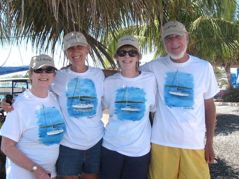
I mentioned shirts and hats in the prior post:
WARNING: The rest of this post is likely to have little appeal to those who are not interested in sailing.

We also did some things for ILENE while in the marina. I had fortuitously found the sheared off head of an Allen bolt (a bolt with a hexagonal pit in its head) lying on the deck; it should have bounced off into the sea, unnoticed. But finding it, I  poked around and discovered that it had come off one of the two bolts that holds the cage of the furling line drum to the bottom of the forestay. Here is a picture of the drum. When we pull on the aft corner of the sail to unfurl it, we loosen the white line with green markings shown in the lower left, which gets wrapped around the drum. When we want to put the sail to bed, by pulling on the same white cord with green markings, the sail wraps up on itself on the forestay, of which you see only the bottom inch.The lower photo shows the bottom of the drum, with the Allen bolt in the center. I had thought that as long as the bolt’s shaft was screwed in place, the cage would hang together but I showed the problem to our rigger. He showed me that the threads at the head end of the bolt had been properly intentionally ground off and hence that the remaining lower threaded shaft of the bolt, without its head, was holding nothing. So he took the broken shaft out and put a new bolt in place.
The  rigger had been called primarily to fix our boom vang. He replaced the rivets which had failed with stainless steel machine bolts for which he tapped threads and applied a strong adhesive, Dow’s 5200, as a barrier to prevent corrosion of the aluminum against the steel. He pointed out that the winch mounted on the starboard side of the mast is attached with Stainless steel screws, which persuaded me that stainless steel could work with aluminum. He also freed a frozen pivot point which he said may have been the cause of the vang’s failure. Four of the bolts are shown to the left of the blue line at the right of the photo, with four more holding it on the port side. The formerly frozen up-and-down pivot point is show with a wire circlip hanging from it in the center of the photo.

We polished some stainless, took on some water and some diesel, attached the big horizontal fins at the base of the outboard,  and finally got the piece of madras cotton we had obtained in Guadeloupe hemmed. This last was done by Sharon, who with her husband Larry, are sailing a 44 foot Pearson ketch, “Avatrice”

out of Freeport Maine, where we had visited on ILENE in 2008. Freeport is the home of L.L. Bean. Sharon teaches women how to sail aboard Avatrice in the summers and has a sewing machine aboard. They have GPS but not a chart plotter, preferring to navigate a bit more like the old fashioned way.  They are going our way and we hope to meet up with them along the way. And I got a haircut and a beard trim so I don’t look as shaggy as Darwin any longer.
                 A bit of high excitement happened one afternoon while we were away snorkeling. A 31 foot Freedom sloop, while looking for a mooring in a bay near our marina, took instruction from a passing boat. Either the advice was erroneous or it was heard incorrectly, but after turning, a coral head caught the boat, and punched a hole in it. The boat is considered “totaled” for insurance purposes. Our marina staff, hearing the mayday calls, organized a rescue and no lives were lost. The only injury was to the mate, who, while in their dinghy, got bruised by the anchor line which had been set out to try to prevent further damage. It snapped taught against her arm. Next day, the couple went out to try to salvage a few personal effects. All any of us sailors can say is:  “There, but for the grace of God, go I.”
Posted from Georgetown, Great Exuma, Bahamas.

Tuesday, April 3, 2012

Judy and Meridel and Turks and Caicos - Part I


[Computer charger cord finally came in today, April 3, so we are back in the blogging business from George Town!]

Judy and Meridel are two lovely ladies from Portland Oregon who have been Lene's friends for 18 years, and mine for the last 15 but despite a lot of travel, had never before visited Turks and Caicos.

We beat our way the 16 miles from the uninhabited Big Sand Cay, to Grand Turk (north and then east) in relatively light wind, passing the west side of Salt Cay, where Judy and Meridel were that day. We tied up to the dock there to facilitate the embarcation of our guests the next day; what a mistake! The dock's surface was five feet above ILENE's deck and while I could scramble up and down, the guests would not have been able to do so. Also, this height difference meant that the concrete dock edge was chewing through our mooring lines. And to make matters worse, they charged an additional $20 "berthing fee" for the privilege. So as soon as I had filled out the papers and paid the $50 entry fee to Customs, we slipped from the dock and anchored about 50 yards off the ferry dock. Next to us was "Tamera Sue" which had been part of the flotilla crossing the Mona Passage. Tammy and Joe took off our three bags of garbage to the dumpster, later gave us two mangos and located a restaurant on the beach near where a Holland American liner had just departed.


Next morning after finishing cleaning we were waved at from the 40 foot ferry boat. Its operator let me tie up to the ferry, which was the only convenient way for Meridel and Judy and their luggage to come aboard ILENE.Our guests listened patiently to the full safety lecture: fire, water, man overboard and abandon ship, they selected berths, and we exchanged gifts -- hats and shirts. They unpacked other treats for the kitties a special salad dressing for Lene and life preservers for the cats. have you ever seen a less happy cat?
We dinked to the beach near the restaurant to see the island and then a disaster struck: well disaster is too strong a word, but Lene fell out of the dink while disembarking, soaking herself,  but worse,  her blackberry. Even immediate drying and emersion in a bag of rice would not revive it; but Verizon let her transfer her account to my Blackberry, which is why it is not a disaster.  We rented a car and toured Grant Turk: Its charming old sea side village;

lunched at the Osprey Inn;


and visited the supermarket, drugstore and postoffice and the historic Northeast Lighthouse.

It was built in England and shipped and reassembled here in the 19th century to warn shipping off from the reef, extending 2.8 miles northeast from the island, top right.
It reminded me of NE point on Block Island, but more rocky.
Tammy Sue had also told us of a parachute ride business which was taking out guests for free to train their crew and we took a ride-- high and exciting. Ladies first, just after launch and them Roger before take- off and high.


Next day another near disaster: As we were putting up sail, Lene went up to take Alphie from her favorite perch -- in the stack pack,


and got whacked on her left forehead by a short motion of the boom. Only witnesses, the truth, my reputation for gentleness and arnica gel have protected me from accusiations of spousal abuse. Ilene cried for a few minutes and said "I can't go on like this." But a few minutes later, she was back in action.
 We sailed most of the 32 miles to Ambergis Cays -- two small islands shaped like a backward "L" with the corner missing. We gybed first a bit south of west and then a bit north, to get the wind from directly behind us. Then after crossing the Columbus Passage (everyone here wants to claim him) we entered the Caicos Bank.  This meant crossing from water that was 6000 feet deep to only 25 feet deep in much less than 1/4 mile of horizontal distance. The effect is that the waves, which were low out in the deep, got steep as the depth sharply bottomed out.  Once we were on the Bank, we had furled sail as a precaution, the waves became small, but a new problem arose: Coral Heads.  The cruising guide warned us about them-- black against the yellow sandy bottom. Here is one, but it is not SO black, so maybe its a harmless seaweed clump. The need to look out for them gives rise to the one rule for crossing banks at night: "Don't!"


 So here's Lene, out on the bow, to look for them and hand signal me to turn right or left to avoid them.


There were more of them in the last few miles from entry on the Bank to Ambergris than the rest of the way. I once turned back, seeking a clearer way through them and we were not used to them yet. Big Ambergris is the site of a failed development project and is private, inhabited, and has an airfield  but did a poor job of sheltering us from the wind. It is ringed by reefs and shallow water and we anchored in 12 feet of water with 100 feet of  chain out. we were a mile from each key-- in the middle of nowhere.
Eventually we saw another sailboat, a mile from us, but the water was choppy and we did not explore.


 A cheesy snack before dinner:

 We did get a good night's sleep after Lene taught our guests a new card came -- and Meridel won!

Next day was the 32 miles from Ambergris to French Cay, across the southern part of the Bank in 12 feet of water -- the same depth as much of ILENE's home in Eastchester Bay, but oh so visible feet here.  It was calm and though we put up the main, we motored all the way. It was like sailing in an acquarium with its visible sandy bottom showing each clump of seaweed and rock. This photo shows our shadow on the bottom: left to right, the anchor hanging down, the forestay, Roger on lookout, and the mainsail, with bits of grass on the bottom. Next sunbeams, reflected on the surface by the alabaster clouds:


French Cay is a sandbar about .2 by .4 miles. We anchored behind it in 12 feet of water and dinked 300 yards to shore. It is a wildlife sanctuary and various flocks of birds were soaring overhead and screeching. The book says no one should land but there was no one else there to complain about our entry except "Viau" who we had passed during the passage.

 I saw flocks of piping plovers skittering along the beach, the same birds whose nests have caused areas of North Shore Long Island beaches to be roped off.  I saw the footprints of others. We soaked in the warm waters. Snorkeling was not done because it would have required anchoring the dink over a reef, which harms the reef and would require climbing back from the water into the dink, which our guests thought that they could not manage.We invited Jens and Hanne of Viau for a shared dinner.
They brought fish balls, a delicious dipping sauce and a bottle of wine. We made steaks and chops and
veggies and rice.  Jens was the organizer of our little flotilla from Puerto Rico. They live near Copenhagen and have excellent English. Meridel and Judy enjoyed the sailing talk even though they did not understand all of it. Meridel, Hanne and Lene, followed by Roger and Jens:


And humans can't have all the fun!
Our final sea day with our guests was from French Cay to the Southside Marina in Providenciales, called Provo by everyone. It is on the big developed northwesternmost Caicos, about 16 miles to the north. This meant some type of beam reach. In light air we flew full main and genoa and hit 7 knots for a bit, but the wind was too light to be exciting. We enjoyed a breakfast of pancakes filled with diced mangos, garnished with papaya,


and delayed our departure until 1:30 pm in order to try to arrive at 5 pm at the height of the tide.


 Lene, Judy (who took a lot of these photos and hence is not in them) and Meridel:


Bob Pratt, the marina owner, came out in a motor boat to the second of two waypoints he had given us, to pilot us in. Even at that, we briefly touched the sandy bottom on the final approach into the Marina where a bar had formed. Southside Marina is a small (12 slips), well run, owner operated and occupied business hewn and dredged out of the limestone strata that comprise the island.  Slips are only $50 per night and there are many services for residents: rides to markets and the barber, a cheerful daily weather report on a VHF communications net, and a daily BYOB (and bring your own snacks) to share at a happy hour under the gazebo which foments familiarity and camaraderie among the boaters. And here, after our first happy hour, the sea based part one of our visit with Meridel and Judy ended.