John and I visited our mutual friend, former HYC member Nick, at the Hebrew home for the Aged in Riverdale, The Bronx, overlooking the Hudson. He has a nice single room with river view but we met him downstairs and had a pleasant time with him. Both John and Nick are retired carpenters and both agree that Nick taught John how to sail. We three will get together later this summer with some other current and former Harlemites and take Nick out for a day on the water. John left me in Manhattan and drove back to Maryland while I got picked up by Steve (who took us for a powerboat ride in Florida) to my first meeting of the Book Group, at the home of former Harlemite, Jim, in Chatham NJ, for a lovely evening with To Kill A Mockingbird.
I visited ILENE for about three hours by subway to pick up some things, clean and scrub out the refrigerators and empty the bilge. I also planned to "pickle" the water maker for winter. Winter is a long way off you might say. Well the water maker is a great tool for remote places where fresh water is difficult to obtain, but a burden in that it requires that it be flushed out for three minutes every five days. I can do this either by visiting the boat, or by leaving the electricity and fresh water pump on, in which case it will do this every five days, automatically. Another thing: It needs non-chlorinated water, the type it makes, for the flush. We have taken to keeping city water in the port water tank for our own use, and making non-chlorine water in the starboard tank for flushing. This also means changing the source of water to the fresh water pump to be from the starboard tank when we are about to flush and back again after the flush. A nuisance, and it means we use the water from only one of our two tanks. So this summer, when city water is available everywhere we plan to go, we have decided to shut down the water maker. This requires propylene glycol, the pink antifreese [My computer's keyboard requires me to substutute as "s" because it's key for the correct letter is broken] we use in the fresh water system and heads. I have to buy two gallons of the stuff, so another visit is needed -- in the next five days -- to do this job, and others.
I also calculated the mileage, dock to dock, for the nine planned passages of the Harlem's 2015 cruise to Block Island and consulted with PC Bruce, who laid out the itinerary. Next step is to figure out what time the tide is favorable on the days for each of those nine passages, especially at the eastern exits from Long Island Sound, where the currents run wicked fast. I contacted (1) Barnacle Buster to set up a bottom cleaning schedule and to enlist him to fix the prop rattle by adjusting or removing the Spurs line cutter, and (2) my insurer, Pantaenius, to reduce the geographic scope of our coverage, now that we will not be going south of NY for the next few years.
Coming your way within weeks will be a statistical compilation of the 230 days of our winter's cruise: passage days, miles per passage, total miles, nights on anchor-mooring-dock-or at sea, number of ports visited and how many times in each, how many were new first-time ports for ILENE, average number of lay days per port, how many lunches and dinners off the boat, etc. Yes, I am a confessed compulsive quantifier. I have done this following our prior long cruises. You could do it yourself if you were so inclined -- or should I say possessed) based on the data in the posts of this blog.
., ,
Saturday, May 30, 2015
Friday, May 29, 2015
May 25-26 -- Cape May to Atlantic Highlands to Our Home Mooring at City Island -- 115 and 34.6 Miles
John's boat's chartplotter, though the same brand, is different from the one installed on ILENE. John never got comfortable with mine: He asked "Don't you have pages and scroll between them?" "No John, but by hitting "display" and two other buttons you get the same effect." This put me in mind of my own discomfort in using the more advanced plotter on Pandora last fall, which was unfamiliar to me. Familiarity breeds comfort.
John and I had several debates during the day. He is more cautious and prevailed upon me to adopt the plan which appeared to be safer. I am not an autocratic captain. I welcome and listen to suggestions from others, especially knowledgeable sailors like John, While responsible for making the final decisions (such as the passage around Cape May right off the beach), I frequently adopt the suggestions of others. I had plotted out the distance and figured that at the 6.5 knot planning speed, if we left Cape May at five in the afternoon, we would be leaving by daylight and arriving at a buoy off Sandy Hook, 109.8 miles away, in daylight at ten the next morning, in time to catch the incoming tide through New York Harbor. This gave us plenty of time after sunrise in case we were going too fast, and we could always slow down by reducing sail. John listened carefully to the weather reports. They predicted stronger winds at night as compared to by day, though both from the south, so they would be pushing us and not requiring us to beat. He said that if we motor sailed and could make eight knots and left at 5:30 in the morning, we could get in before dark at 8:30 to an anchorage behind Sandy Hook marking the southern entrance to New York Harbor. I agreed to this plan and we got underway at 5:30 AM for a daylight passage.
In fact, we did not anchor until sixteen hours later, at 9:30 PM, about an hour after dark, because of three factors: First the wind was too light, at first, to move us at quite a fast enough speed, even with the motor. We were running away from the wind on almost a dead run, with the big ocean waves rolling the boat and shaking the wind out of the sails, reducing apparent wind speed. In fact we took down the main because it was useless and proceeded under only the small jib and motor. Second, all of a sudden the engine shut down and it took me about five minutes to switch from the tank of fuel we had been using to the other tank, locate the hand lever on the engine which is used to pump fuel to the engine, pump this lever 30 times and restart. That lever is small and in a wickedly devilish location: I can reach it but not see it and have to grope blindly around the starboard side of a very hot engine to find it. We could not be out of fuel in the first tank having filled it only two days before, so a bit of impurity in that tank, such as water, must have been shaken up by the rough seas to cause the problem. Third, about three PM, out of nowhere (though we were passing over big ocean roller waves), the propeller rattle reappeared suddenly, with a vengeance, and we cut the engine speed from 2700 rpms to 1500, which slowed us considerably. I immediately replaced the small jib with the genoa and with the wind picking up considerably, we got most of our speed back.
In the morning we saw this rig,
 with a pipe floating on the water between the two vessels. This may have been an oil spill containment operation or dredging. Just don't cut between the two vessels! [An astute reader has advised that it is dredging -- not to make the ocean deeper but to recover sand blown away by Hurricane Sandy to rebuild the beaches. Thanks for the input Jeff!]
John and I had several debates during the day. He is more cautious and prevailed upon me to adopt the plan which appeared to be safer. I am not an autocratic captain. I welcome and listen to suggestions from others, especially knowledgeable sailors like John, While responsible for making the final decisions (such as the passage around Cape May right off the beach), I frequently adopt the suggestions of others. I had plotted out the distance and figured that at the 6.5 knot planning speed, if we left Cape May at five in the afternoon, we would be leaving by daylight and arriving at a buoy off Sandy Hook, 109.8 miles away, in daylight at ten the next morning, in time to catch the incoming tide through New York Harbor. This gave us plenty of time after sunrise in case we were going too fast, and we could always slow down by reducing sail. John listened carefully to the weather reports. They predicted stronger winds at night as compared to by day, though both from the south, so they would be pushing us and not requiring us to beat. He said that if we motor sailed and could make eight knots and left at 5:30 in the morning, we could get in before dark at 8:30 to an anchorage behind Sandy Hook marking the southern entrance to New York Harbor. I agreed to this plan and we got underway at 5:30 AM for a daylight passage.
In fact, we did not anchor until sixteen hours later, at 9:30 PM, about an hour after dark, because of three factors: First the wind was too light, at first, to move us at quite a fast enough speed, even with the motor. We were running away from the wind on almost a dead run, with the big ocean waves rolling the boat and shaking the wind out of the sails, reducing apparent wind speed. In fact we took down the main because it was useless and proceeded under only the small jib and motor. Second, all of a sudden the engine shut down and it took me about five minutes to switch from the tank of fuel we had been using to the other tank, locate the hand lever on the engine which is used to pump fuel to the engine, pump this lever 30 times and restart. That lever is small and in a wickedly devilish location: I can reach it but not see it and have to grope blindly around the starboard side of a very hot engine to find it. We could not be out of fuel in the first tank having filled it only two days before, so a bit of impurity in that tank, such as water, must have been shaken up by the rough seas to cause the problem. Third, about three PM, out of nowhere (though we were passing over big ocean roller waves), the propeller rattle reappeared suddenly, with a vengeance, and we cut the engine speed from 2700 rpms to 1500, which slowed us considerably. I immediately replaced the small jib with the genoa and with the wind picking up considerably, we got most of our speed back.
In the morning we saw this rig,

I had studied a recommended anchorage off the Coast Guard Station on the west side of Sandy Hook near its northern tip. This was recommended for easy access, not far from the route between NYC and the Atlantic coast of NJ, except in westerly winds, which could build up a big fetch crossing Raritan and Sandy Hook Bays. John said, "Yes, but it is also exposed to southerly winds if they are as strong as 35 knots, which are predicted." So again I listened to the wisdom of my cautious crewmate and we traversed the three miles further south to the anchorage behind the seawall which runs EW along the southern coast of Sandy Hook Bay, protected from the southerly winds by the massive Atlantic Highlands. We had rigged up and tested the million candlepower flashlight to have it readily available if needed. Arriving at the seawall there was what appeared to be a large dredge in its entrance and we could not determine whether to try to pass north or south of it, so we anchored outside the seawall. This would have been foolish in northerly winds which would be trying to push us into the seawall, but the southerly winds made this an easy roomy anchorage. Seventy feet of snubbed chain in 13 feet of water. A sixteen hour day, followed by leftovers, which tasted even better a day later.
The next morning was the final passage of this winter's cruise. We had a big leisurely breakfast and I gathered many of the things I planned to take home before a 9:30 departure. This departure was half an hour before planned and 2.5 before ideal, due to a mistake I made in reading the currents in Eldridge's great tide book. I used data from Sheepshead Bay rather than from Sandy Hook, and they differ. And we had up only the small jib and double reefed main in anticipation of heavy winds from the south in the crowded twisty upper harbor. But those winds had not arrived yet, the tide was adverse, and with low rpms, it took us three hours to get to the Battery.
 Along the way we saw West Bank lighthouse, one of several in New York's lower harbor, two massive DDGs departing from fleet week in the city, and a good looking Coast Guard Cutter.
A NYC fireboat was giving the Navy and Coast Guard vessels a full water cannon salute. We thought that we might benefit from this display as a welcome back but as soon as they passed, the Fireboat shut down and moved off.

The high speed ferry ripped past us, returning to Atlantic Highlands for another load of commuters to wall Street.

And of course the unmistakable skyline with the Freedom Tower towering above all the other skyscrapers from the background.
 About then the flooding tide cut in, whooshing us up the East River and through Hellgate. Once past the Gate there was plenty of wind on a beam reach for the last half hour or so of glorious sailing to ILENE's mooring. We arrived at 2:30 and we're off by 4:30 driving to our apartment in John's car by six and a delicious dinner at a Greek restaurant in the neighborhood. Grilled octopus salad anyone? I love the fact that my longest cruise ever ended with such a terrific sail with the small sails giving us all the speed we could handle.
Cruising is great but Ah Home! Stay tuned, this blog will continue during the summer season and, God willing, beyond.
The next morning was the final passage of this winter's cruise. We had a big leisurely breakfast and I gathered many of the things I planned to take home before a 9:30 departure. This departure was half an hour before planned and 2.5 before ideal, due to a mistake I made in reading the currents in Eldridge's great tide book. I used data from Sheepshead Bay rather than from Sandy Hook, and they differ. And we had up only the small jib and double reefed main in anticipation of heavy winds from the south in the crowded twisty upper harbor. But those winds had not arrived yet, the tide was adverse, and with low rpms, it took us three hours to get to the Battery.

A NYC fireboat was giving the Navy and Coast Guard vessels a full water cannon salute. We thought that we might benefit from this display as a welcome back but as soon as they passed, the Fireboat shut down and moved off.

The high speed ferry ripped past us, returning to Atlantic Highlands for another load of commuters to wall Street.

And of course the unmistakable skyline with the Freedom Tower towering above all the other skyscrapers from the background.

Cruising is great but Ah Home! Stay tuned, this blog will continue during the summer season and, God willing, beyond.
Thursday, May 28, 2015
May 23 - 24 -- St. Michaels to Chesapeake City to Cape May -- 68.9 and 68 Miles
The first day of this holiday weekend John and I got underway at 7:15 after I water taxied Lene and the felines in their carrier to John's car and we raised and secured the dink. And we docked at 8 pm. But we were not actually underway the whole time. We detoured into Annapolis after passing about eighty boat flying spinnakers, racing the other way, headed from Annapolis to St. Michaels. We stopped in Back Bay to fill the fuel tanks, which took an estimated 90 minutes of in and out and waiting on line for the fuel dock with only about 15 of those minutes for the actual fueling.
Our second stop of the day was when we run into the mud trying to enter the harbor on the south side of the C and D Canal, where I had stayed in 2006 on ILENE and last fall on sister ship Pandora. We backed right off the mud and tried to call the marina by phone and VHF. Finally, the person said, "I don't know if you can make it in now, near low tide, but hug the seawall on the left side of the entrance." This was not very reassuring. We had noticed a long high fixed dock with two or three small power boats tied up to it and a busy restaurant on the other side of the canal, less than a quarter of a mile back- Scheafers. Not seeing any sailboats there, I called to ask about depth and they said they had 20 feet minimum at the dock, which our depth meter later confirmed. But they "had to charge us their holiday rate", $2.50 per foot. The restaurant and bar were large and jammed with revelers. We had dinner there and the food was OK. It seems the place burned down about ten years ago and has recently reopened. It is so easy to get in and out that this will be a place I'll return to, even though they do not have water, electricity or wifi.
Why did it take so long, you might ask. Well the tides were against us all day. We went down the Miles River from St. Michaels against the flood which turned to ebb when we rounded Bloody Point to go north up the Bay. Six hours later this should have changed but then we were confronted by water flowing toward us from the Delaware. Well we have had all-day good tides too, but not today.
John was great help all day, a knowledgeable cautious seaman.
 His 28' S2 sloop, "Hearts Content" passed its survey the day before with flying colors. "The best maintained 35 year old S2 I have ever surveyed" said the surveyor. She was John's friend for the last 25 years, but he also has a 22 foot power boat, "Dixie," and he was not using the sloop and has found her a good home. Second happiest bittersweet day in a man's life: when he sells his boat.
Next morning we continued in the canal starting at 7:15 and found favorable tide. Belt and suspenders, do you think:
 No, just an optical illusion with the arch further away and the pretty suspension bridge that Lene drove over the day before in the foreground.
Once in Delaware Bay, the tide was an even bigger help and we made over nine knots until noon. Delaware Bay is a wide boring passage except when freighters pass you by. See bow wake.
 As the day wore on, the wind came up strongly, with about 35 knots and gusts to 45 showing on our meter, (though I sense that it reads about five knots too fast). So we had only the small jib and were beating down the Bay. The tricky part was rounding Cape May. The outer passage is a long way around some shoals, which would have added about the miles to our trip in rough weather toward the end of the day. The inner passage saves those miles but put ILENE's port side only about .2 miles from the beach with those big winds and the big waves they created trying to push her onto the beach. We had furled the small jib to gain control over safety for this part of the passage. John wanted the more cautious longer passage, as had part of my crew in 2006 when we did this in calmer weather. We have pictures of the beach with its lighthouse taken from this in close route on this blog in June 2012, on a rather calm day and had done the trip in the opposite direction last fall. Today we were too busy for pictures. it was a two person operation. John steered or to be more precise, controlled the autopilot and watched the waves. One of them sent a spray of water up over the boat soaking him completely. My job wasq operate the InavX on Lene's Ipad, while crouched in the companionway, to protect it from the spray and shade it from the sun. I directed, for example: "Turn right ten degrees." It was like instrument flight rules or sailing in thick fog. I directed our course from the electronic chart, around shoals charted as little as nine feet deep, keeping us in water at least 13 feet deep, without looking up to see where we actually were or where we were going. It was scary but we made it.
Once around the Cape, we turned more north toward the two stone seawalls that mark and protect the channel entrance into Cape May Harbor from the Atlantic. It seemed that we would be surfing down waves barreling directly into the harbor so I turned toward the beach for a practice run in that direction and ILENE seemed to handle it well. In the reality, however, the waves were at about a twenty degree angle from the channel and our passage between the seawalls was relatively easy. We anchored near the Coast Guard Station in about ten feet of water off the green side of the channel with sixty feet of snubbed chain. We were one of about six boats there, each far enough from the others and protected from the SW winds by the land mass of the Cape. John was a bit nauseous, though more from nerves than motion sickness, I think.
We were in by 5:30 and after a breather it was time for dinner. I have tried to get John to try foods that, while within his vegetarian practice, were different from his routine. Tonight we shared his food. I sauteed and steamed some veggies, fake chicken strips and onions, mixed them with whole wheat pasta and dressed it with soy sauce and grated cheese. Pretty good, and it better be because the leftovers is tomorrow's dinner too.
Our second stop of the day was when we run into the mud trying to enter the harbor on the south side of the C and D Canal, where I had stayed in 2006 on ILENE and last fall on sister ship Pandora. We backed right off the mud and tried to call the marina by phone and VHF. Finally, the person said, "I don't know if you can make it in now, near low tide, but hug the seawall on the left side of the entrance." This was not very reassuring. We had noticed a long high fixed dock with two or three small power boats tied up to it and a busy restaurant on the other side of the canal, less than a quarter of a mile back- Scheafers. Not seeing any sailboats there, I called to ask about depth and they said they had 20 feet minimum at the dock, which our depth meter later confirmed. But they "had to charge us their holiday rate", $2.50 per foot. The restaurant and bar were large and jammed with revelers. We had dinner there and the food was OK. It seems the place burned down about ten years ago and has recently reopened. It is so easy to get in and out that this will be a place I'll return to, even though they do not have water, electricity or wifi.
Why did it take so long, you might ask. Well the tides were against us all day. We went down the Miles River from St. Michaels against the flood which turned to ebb when we rounded Bloody Point to go north up the Bay. Six hours later this should have changed but then we were confronted by water flowing toward us from the Delaware. Well we have had all-day good tides too, but not today.
John was great help all day, a knowledgeable cautious seaman.

Next morning we continued in the canal starting at 7:15 and found favorable tide. Belt and suspenders, do you think:

Once in Delaware Bay, the tide was an even bigger help and we made over nine knots until noon. Delaware Bay is a wide boring passage except when freighters pass you by. See bow wake.

Once around the Cape, we turned more north toward the two stone seawalls that mark and protect the channel entrance into Cape May Harbor from the Atlantic. It seemed that we would be surfing down waves barreling directly into the harbor so I turned toward the beach for a practice run in that direction and ILENE seemed to handle it well. In the reality, however, the waves were at about a twenty degree angle from the channel and our passage between the seawalls was relatively easy. We anchored near the Coast Guard Station in about ten feet of water off the green side of the channel with sixty feet of snubbed chain. We were one of about six boats there, each far enough from the others and protected from the SW winds by the land mass of the Cape. John was a bit nauseous, though more from nerves than motion sickness, I think.
We were in by 5:30 and after a breather it was time for dinner. I have tried to get John to try foods that, while within his vegetarian practice, were different from his routine. Tonight we shared his food. I sauteed and steamed some veggies, fake chicken strips and onions, mixed them with whole wheat pasta and dressed it with soy sauce and grated cheese. Pretty good, and it better be because the leftovers is tomorrow's dinner too.
Tuesday, May 26, 2015
May 19-22 -- Solomon's to St Michael's and Three Lay Day There -- 50.7 Miles
Underway 9:30 to 5:45. Winds "light and variable" said NOAA. And they were directly from the north until noon when we put up the rags as our course came to 020 and we were on a starboard close hauled reach which broadened. We passed some interesting sights. Cove Point Light disproved my prior assertion that there are no pretty lights in the Chesapeake.
 Night passages require you to keep in the center to avoid unlighted fish weirs like this one, quite a ways off shore.
 This is part of a dock for the off loading of liquid natural gas into tanks ashore.
 A voice on VHF told a boat passing closer than a quarter mile to keep off - security zone.
For about an hour we sailed without the engine, at about four knots; light and variable. Back to engine when our speed got down to two knots. Lene heard something funny and reported that no water was coming out of the salt water cooling exhaust, so we quickly turned the engine off and continued slowly under sail. I checked the intake of seawater into the boat and it was not clogged. So we tried again and either we had not had a problem in the first place or it went away spontaneously. Warm seawater spurted out of the exhaust, again.
Our friends, Mike and Janet, ex Harlemites whose lovely home we visited in Ft. Pierce, FL, have their summer home here. Janet scouted out the anchorages, which get crowded on beautiful summer weekends. In 2006 we came here twice and docked once at the marina and once in the Maritime Museum. But it was Tuesday and before Memorial Day, and there were no other boats on anchor so we came into the small inner harbor, in eleven feet of water on 65 feet of snubbed chain. This was preferable to the large but exposed anchorage out in the river where it is about 18 feet deep. Our private cove.

Lene looks happy after the passage, her last of this winter, and her smile makes her look great, but then again she always looks great.
 During the night the wind came up and either we dragged a bit or our rode got stretched out straight in a different direction. Either way, we appeared closer to the land behind us so we picked up and reanchored.
We dinked in to the public dock and bought groceries at Acme. I got both a postcard and an outfit for my granddaughter when we toured some of the local shops. Returning to land after lunch, we were picked up by Mike, driven around town and to their great home where we hung and talked about old times.
 Later we enjoyed dinner with them at the Miles River YC. Yum. A very nice club with an active racing program including Star class boats that are stored ashore and winched down into the water for races. They also race dugouts which are very old fashioned wooden boats with three sails. Their interesting quality is that in lieu of a keel, they use people, as many as four per board, as many as four boards, tucked under the lee gunnel and extending about ten feet out the other side. There crew members are human ballast, leveraged to keep the boats upright. In the Chesapeake Bay Maritime Museum they show a video of these races. Wild! The same sort of idea are raced in Geogetown in the Exumas, Bahamas.
It was the next day, after we had sweet potato mango pancakes at Mike and Janet's house, that I visited the museum, seen here from the dink tied to ILENE, with its screwpile lighthouse.
 First thing a saw was this T-shirt, which I did not buy.
 It further gives the lie to my prior assertion that none of the Chesapeake lighthouses are pretty. It was raining all day.
Another boat came in while Lene was aboard and I was in the museum, and anchored near us. Pretty close but not two close, seen here at sunrise the next day. During our last night, three others crowded in as well.
 I spent some time talking with the volunteers who build and repair wooden small craft in the museum's boathouse. I learned how they make round masts and spars: they start with a square log and plane off its four corners resulting in an octagonal one. Next step makes it a sixteen sided and then 32 sided, which appears round, but it is sanded with paper stretched across a frame so it has a rounded surface. Neat tricks.
 The center of the museum is an exhibit on the myriad ways that folks have used the water of the Bay: as a livelihood, for pleasure as housing and the myriad variations of boat racing, yacht clubs, camps, fishing, etc.
One three-tree "canoe" exhibited in the boat shed was placarded as having a beam of 6'2''. No way was it that wide; I told the museum people.
Mike and Janet lent us their car on our last day and we drove for sightseeing in nearby Easton and visited its art museum. There we met John and did some provisioning. John drove back with us in his car in preparation for his voyages for the rest of this cruise, from here back to NYC. This gave Lene the opportunity to drive his car to NY and park it at the Club so John and I will be able to offload perishables and necessaries back to our apartment and he will have wheels to get home to Cambridge MD. This also means that Lene avoided the NYC - Chesapeake passages on both ends of this cruise.
We had planned only one lay day in St. Michaels, two in the Wye River, which we loved in 2006, and two in Annapolis, before the start of the passages home. An all day rain killed off the Wye River and John's schedule made it better for all us to leave from St. Michaels for home. It seems that plan B usually wins out over plan A.


Our friends, Mike and Janet, ex Harlemites whose lovely home we visited in Ft. Pierce, FL, have their summer home here. Janet scouted out the anchorages, which get crowded on beautiful summer weekends. In 2006 we came here twice and docked once at the marina and once in the Maritime Museum. But it was Tuesday and before Memorial Day, and there were no other boats on anchor so we came into the small inner harbor, in eleven feet of water on 65 feet of snubbed chain. This was preferable to the large but exposed anchorage out in the river where it is about 18 feet deep. Our private cove.

Lene looks happy after the passage, her last of this winter, and her smile makes her look great, but then again she always looks great.

We dinked in to the public dock and bought groceries at Acme. I got both a postcard and an outfit for my granddaughter when we toured some of the local shops. Returning to land after lunch, we were picked up by Mike, driven around town and to their great home where we hung and talked about old times.

It was the next day, after we had sweet potato mango pancakes at Mike and Janet's house, that I visited the museum, seen here from the dink tied to ILENE, with its screwpile lighthouse.


Another boat came in while Lene was aboard and I was in the museum, and anchored near us. Pretty close but not two close, seen here at sunrise the next day. During our last night, three others crowded in as well.


One three-tree "canoe" exhibited in the boat shed was placarded as having a beam of 6'2''. No way was it that wide; I told the museum people.
Mike and Janet lent us their car on our last day and we drove for sightseeing in nearby Easton and visited its art museum. There we met John and did some provisioning. John drove back with us in his car in preparation for his voyages for the rest of this cruise, from here back to NYC. This gave Lene the opportunity to drive his car to NY and park it at the Club so John and I will be able to offload perishables and necessaries back to our apartment and he will have wheels to get home to Cambridge MD. This also means that Lene avoided the NYC - Chesapeake passages on both ends of this cruise.
We had planned only one lay day in St. Michaels, two in the Wye River, which we loved in 2006, and two in Annapolis, before the start of the passages home. An all day rain killed off the Wye River and John's schedule made it better for all us to leave from St. Michaels for home. It seems that plan B usually wins out over plan A.
Tuesday, May 19, 2015
May 17-18 -- St Mary's to Solomon's and Lay Day There -- 38.9 Miles
Seven am to 2 pm. We motor sailed down the St. Mary's River and out of the Potomac. When we turned north in the Bay, we jibed the main, replaced the small jib with the Genoa, shut off the noise and enjoyed a wonderful beamy port reach, almost to the mouth of the Patuxent River. Here we are passing behind Point No Point Light, with plenty of depth for us.
 We were doing seven plus, with favorable tide but the wind gradually diminished. The seas were glassy, indicating no wind, but the wind indicator, 63.5 feet above the water, showed some wind and we were moving at four knots, well above the rate of the tidal flow. But the wind gradually slowed, as did our speed, to three knots, to two, and then we turned on the engine again. Solomons is only about ten miles from St. Mary's as the crow flies, across the neck of land between the Potomac and the Patuxent, but almost four times as far by sea.
We had been to Solomons in 2006, when we docked at the Yacht Club. In 2012, we missed this port when we holed up during a windstorm. This time the threat of another thunderstorm caused us to moor ($30/night) at Zahniser's Marina, at the pencil point. It has been warm and sunny here by day.
 We have use of their dinghy dock, showers, garbage disposal, swimming pool (though we did not use it) and loaner bikes. Solomon's was bought by Isaac Solomon in 1865 to use as a trading and fish packing place. It was an island then but land fill at the far end attached it to the land. This place is chock full of 17 marinas, yacht Clubs and boat yards, with room to anchor in the other inlets up the eastern branches (the chart is unfortunately displayed with west at the top). We took showers, and used their bikes to go shopping and then to dinner at the eclectic CD Cafe. Our marina also has a barbecue area, (but we did not have charcoal). There we met the owners of s/v Baby B, a Saga 40, in great condition. Many people keep their boats here and drive for hours to enjoy them on weekends.
The first half of our lay day was for chores and then we split up: Lene got the solitude she sought and I visited the Calvert Maritime Museum (and Westmarine, where I managed to buy absolutely nothing!) It turns out that today was National Museum Day, which meant I saved the $9 senior admission fee. They have an outdoor nature station with information about local water grasses and wildlife, a great habitat for the resident otter, an aquarium, lots of stuff for kids, and lots of stuff for me too.
 Ned, my docent for a guided tour of the Drum Point Light, which was moved here when it was decaying.

 There are only two others of these screwpilers left. One is at the Chesapeake Maritime Museum at St. Michael's (across the Bay and our next stop) and one is still in use, near Annapolis. These screw pile lights are the only pretty ones in the Chesapeake, in my opinion. The wooden handle, below, is to pump up a 150 pound weight, which descends gradually during the next two hours, causing the heavy hammer to strike the outside bell through a removable panel between the windows, twice every fifteen seconds to warn during fog when the light cannot be seen.

ILENE's mast and forestays are visible behind the trees, to the right, from the top of the light.
 And tthe museum has boats, of course, lots of boats. I learned that in the War of 1812 the British attacked cities along the Patuxent until they made a land dash from high up the river across to Washington DC, which they sacked. And the mouth of the river was home to three huge military facilities during WWII, for naval aviation, weapons development and amphibious assault.
They have several beautifully restored wooden pleasure craft, an interesting set of exhibits on wood carving (in the background behind this lovingly restored "dugout" fishing boat and with a display of mid century small power racing boats on the balcony),
 the art of seam filling, blacksmithery and a large section about the excavation of fossils from the nearby riverfront cliffs. A very nice afternoon. The second night's thunderstorm passed at 1 am, without strong winds and with us safely on a mooring.

We had been to Solomons in 2006, when we docked at the Yacht Club. In 2012, we missed this port when we holed up during a windstorm. This time the threat of another thunderstorm caused us to moor ($30/night) at Zahniser's Marina, at the pencil point. It has been warm and sunny here by day.

The first half of our lay day was for chores and then we split up: Lene got the solitude she sought and I visited the Calvert Maritime Museum (and Westmarine, where I managed to buy absolutely nothing!) It turns out that today was National Museum Day, which meant I saved the $9 senior admission fee. They have an outdoor nature station with information about local water grasses and wildlife, a great habitat for the resident otter, an aquarium, lots of stuff for kids, and lots of stuff for me too.


ILENE's mast and forestays are visible behind the trees, to the right, from the top of the light.

They have several beautifully restored wooden pleasure craft, an interesting set of exhibits on wood carving (in the background behind this lovingly restored "dugout" fishing boat and with a display of mid century small power racing boats on the balcony),

Monday, May 18, 2015
May 15-16 -- Colonial Beach VA to St. Mary's MD and Lay Day There -- 35.5 Miles
Cool last night. Lene likes fresh air but we kept the hatches and ports closed. We got a late start this morning, 9 am, and it cost us adverse tide until the last eight miles up the beautiful St. Mary's River, which was a delicious engineless broad port reach to Horseshoe Bend, with diminishing wind that gradually slowed us from eight to four knots as the headlands on either side cut off the wind. Before this, out in the Potomac, the propeller rattle reappeared and we motorsailed with main and small jib. It was slow at first with light wind and then there were 25 knots, but on our nose, requiring us to beat our way down the Potomac. It was Friday and we saw our first substantial river traffic. A tug was pushing a heavily laden barge in Kettle Bottom Shoals Channel. I called and he asked me to stay outside the channel, which I had planned to do anyway. Also about four cruising sailboats and about ten fishing boats dragging vanes to spread out their lines; they take up a lot of room but we had no close calls. Your photographer was inattentive; sorry.
Horseshoe Bend is roughly circular and about two thirds of a mile in diameter, with water in the teens almost to its edges. On its SE side, near where we anchored in 16 feet of water with 100 feet of snubbed chain, is the waterside sailing center of St Mary's College. We are center right. Lots of kids out on skiffs, SUPs, and kayaks. Free use of the school's dinghy dock. A most welcoming place. The school is celebrating its 175th anniversary and has only 2000 students; Lene and I attended much larger schools. St. Mary's is
 an "honor" college of the University of Maryland. It has the only eating facility in the area, its cafeteria, where you can get all you can eat for $13 for dinner. But with graduation on our lay day, we had their last supper, burgers and dogs. We actually attended the graduation ceremony, why not. Rashad Robinson, director of The Color of Change, a million member strong on line civil rights group, gave an address and received an honorary doctorate degree. We stayed until the roll call of the names of the 430 scholars who were awarded their BAs was begun and then toured the campus, which was mostly locked up. We could hear but not see the speakers and a lot more people were seated to the left. The Bend is in the background left. A lovely setting.
 Across the road from the college is "Historic St. Mary's City", which was the capital of the Maryland colony from 1636 to 1695, when they moved the colony's capital to Annapolis. Don't get this place confused with the St. Mary on the St. Marys River at the southern edge of Georgia, where we celebrated Thanksgiving.
 This is the frame of "a lawyer's house" in the former, and possibly future, historic city. It is there to mark where the house was. If they get money they plan to rebuild it as they have some of the houses, stores, a barn a church and the meeting house.
One of the best features is the Dove, built to resemble a supply ship that accompanied the settlers in 1635. This one has a diesel, hidden away in its bowels, and GPS as backup to its octant. It actually sails, once a month, in the St. Mary's River, and once a year it goes further, such as across the Bay.

Here is the Dove's Bos'n, Jeremy, a retired navy corpsman. We enjoyed talking with each other.
 The colony was founded by Catholics who created the first experiment in what our Constitution now calls "the free exercise of religion". But colonial rule was influenced by the religious war in England between Protestants and Catholics, and the experiment was short lived, when the tides of the war turned.
Here is my land docent, (Is it Gretchen, I'm so sorry I forgot your name and Lene discarded the paper on which I wrote it!),
 soon to graduate from St. Mary's with a Masters in Education and return to teaching HS history. The Historic City might become another colonial Williamsburg or Jamestown but is suffers from a somewhat remote location. They are conflicted between two methods of restoration. The expensive way requires mega doses of expert historians to get it right and craftspeople with knowledge of and access to period materials and tools. Much cheaper is to erect a structure that looks kinda like what they think the old building looked like. A complicating factor for them is that the land was put to other uses in the intervening centuries, such as a tobacco plantation with its own greathouse in the 19th Century.
I had never heard of the St. Mary's settlement and it is a very interesting place to visit and easy for sailors, near the mouth of the Potomac.
Our last night, we experienced a 35 knot thunderstorm. I put on instruments and sat in the cockpit to check against dragging, but we were not, and once having sustained winds of that strength, we relied on the fact that the anchor had dug itself in deep, and called off the watch for the duration. Just a bit lumpy out there.
Horseshoe Bend is roughly circular and about two thirds of a mile in diameter, with water in the teens almost to its edges. On its SE side, near where we anchored in 16 feet of water with 100 feet of snubbed chain, is the waterside sailing center of St Mary's College. We are center right. Lots of kids out on skiffs, SUPs, and kayaks. Free use of the school's dinghy dock. A most welcoming place. The school is celebrating its 175th anniversary and has only 2000 students; Lene and I attended much larger schools. St. Mary's is


One of the best features is the Dove, built to resemble a supply ship that accompanied the settlers in 1635. This one has a diesel, hidden away in its bowels, and GPS as backup to its octant. It actually sails, once a month, in the St. Mary's River, and once a year it goes further, such as across the Bay.

Here is the Dove's Bos'n, Jeremy, a retired navy corpsman. We enjoyed talking with each other.

Here is my land docent, (Is it Gretchen, I'm so sorry I forgot your name and Lene discarded the paper on which I wrote it!),

I had never heard of the St. Mary's settlement and it is a very interesting place to visit and easy for sailors, near the mouth of the Potomac.
Our last night, we experienced a 35 knot thunderstorm. I put on instruments and sat in the cockpit to check against dragging, but we were not, and once having sustained winds of that strength, we relied on the fact that the anchor had dug itself in deep, and called off the watch for the duration. Just a bit lumpy out there.
Friday, May 15, 2015
May 14 -- Capital Yacht Club, DC to Anchorage North of Bluff Point, Colonial Beach, VA -- 56.6 Miles
It was cold the past two nights and yesterday and today. So I was warmly bundled for today's 7:00 to 3:45 passage -- a retracing of our path, back down the Potomac. The early start was dictated by the desire to capture a few hours of good tide. We went further than Fairview Beach because we had the time and want to go further tomorrow too. Here is Fairview from the channel, above the gate in the lifelines. It shows that this river is w i d e!

With the wind behind us the small jib self-jibes at will while the other two sails, though they would have given us more speed, would have been a bear to handle through all the jibes of the twisty river. In fact the Potomac is a pretty easy river to navigate, especially once you have been there. Our electronic chart plotter displays the water more than 20 feet deep, the channel, in light blue, with dark blue for the shallower water at the sides. Red and green buoys are shown and we generally respect them, but if you stay in the light blue, you can't go wrong.
Tonight the wind is predicted from the south at 5 to 10 knots so while we elected to stop in the Potomac, rather than in a harbor, we are on the north side of a bluff which should make the 5 to 10 knots of wind from the south easy to take tonight. We have 60 feet of snubbed chain in 11 feet of water and no other boats in sight. For those with Google Earth who want to know, we are at 38 degrees, 16.6 minutes North; 076 degrees, 59.4 minutes West. Here:

 |


Maryland Point Light, with rapids flowing past and many birds watching from the man made islands on both sides.

Tomorrow's destination: St. Mary's, Maryland.
Thursday, May 14, 2015
May 12-13 -- Last Two Lay Days in Washington -- No miles


Our final day was for Congress and the Library of Congress. We had planned to visit the adjacent Supreme Court as well. I had to be admitted to its Bar to oppose a Petition for Certiorari in the late '70's. (Since about 95 to 99 percent of such petitions are denied, winning that one was rather easy.) But our tourism stamina gave out before we got there, which was a shame because Lene has never been there. On our way we passed the Frances Perkins Department of Labor Building.

In 2008 Congress opened a huge underground entrance, visitors center, "Emancipation Hall," with Museum, gift shops, a large cafeteria and many restrooms to handle the throngs of tourists. We were shown an inspirational movie about how well Congress works, which is somewhat of a joke given today's hyperpartisanship. Leah, our assigned

After lunch we visited the Library of Congress through an underground tunnel which avoids having to go through security again. Our first time here.

The entrance hall reminded me of The Hermitage in St. Petersberg, with its staircase, marble, red, statuary and grandeur.
The main reading room is much smaller than the one in NY but more elegant.

Wednesday, May 13, 2015
May 8-11 -- Four Lay Days in DC -- Zero Miles
I have been in this city many times, but only for a day or two. This time we have had the luxury of being able to walk its neighborhoods. We also got senior pass cards for the Metro and enjoyed half price fares for the longer trips. The Capital YC is in the Washington Channel, which runs parallel to the Potomac behind the Jefferson Memorial.

Here are the Washington monument and to its left the White House, from the Jefferson monument. We did not visit these.
 The entire waterfront area, over half a mile long, is the site of a massive construction project. The new Clubhouse should be quite nice when it is completed in the fall of 2017. This club has a large percentage of its members who live aboard. It is about a twenty minute walk to the Mall. We walked to Jefferson and saw his words on the interior. Too bad that Justice Scalia and others on our Supreme Court have never been here or observed what he wrote. They claim to seek to interpret our Constitution in accordance with the original intent of the founding fathers, but give that document a diametrically different twist from Jefferson.

We lucked out to be here on the 70th anniversary of VE Day to see this program
 at the World War II memorial on the Mall, hear a few speeches, and then the big event.

 Next were the Viet Nam War,
 Lincoln, and Korean War Memorials before hiking up through a bit of Georgetown to the Metro
 for a ride to a movie at the Angelica Pop Up, a branch of the movie house on Houston Street back home. These are large modern stations and some are as deeply below ground, it seemed to me, as the St. Petersberg Metro. All escalator access at the stations we visited. We saw "Welcome To Me", about a narcissist with borderline personality disorder who wins the lottery and spends the money producing, writing, directing, and starring in a TV show about her favorite person, herself. Sad but funny. This was in the NE section, at Union Market, which has an eclectic assortment of non-branded food stores. We shared an Indian dish from one and fish and chips from another.
We spent two mornings at the Newseum, a large museum built in this century about the news, journalism and first amendment freedoms. There is more to see in this place but we have only so many days. One drawback is that unlike most government sponsored museums, they charge a fee. Another is a bit of redundancy, caused by the fact that many of the sections are sponsored by private news businesses; so many included clips of the same significant events in their shows. This is actual sections of the Berlin Wall, from the perspective of newscasting about its fall.
 One great small exhibit showed how the NY Herald reported on the assassination of President Lincoln through seven different issues it published the next day, as the story unfolded. The Newseum is located on Pennsylvania Avenue, and has a terrace with a great view of the Capital, though it's beautiful dome is encapsulated in scaffolding.
 Bob and Maria, picked us up, brought us back and treated us to a delicious dinner at their large lovely home in what I call the NW suburbs, though it is located in the District. We caught up on each others' lives, our kids, our activities and our mutual friends. The friendship started in the summer of 1969, when I invited them and three others of my colleagues and their wives to the suburban home of my parents in NJ for a simple barbecue. We were summer clerking at Kaye Scholler. Bob and maria cooked up a very elegant barbecue for us.
John, who was so welcoming and helpful in Cambridge, Maryland last October during our voyage south, came and spent two days with us. Again he was helpful, and one of the two new hatch screens is installed except for the wooden batten (diagonal hole upper left), which is down to be cut with an electric jigsaw to fit the larger frame. But first comes a picture of the old frame on the starboard side.


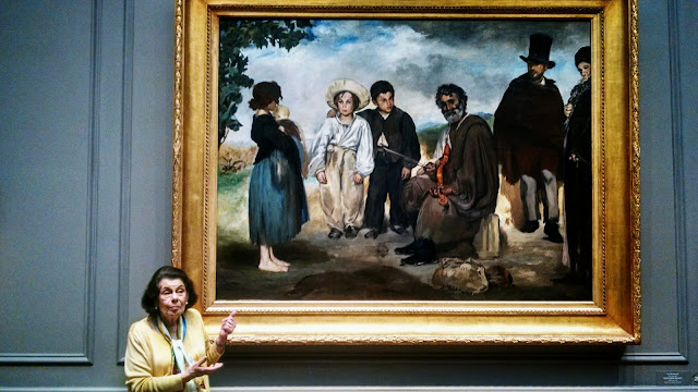
We visited the National Gallery of Art, donated with its contents by a Mellon between the wars. Like a smaller Met in NY but loaded with great art that I had never seen before. Our expert docent is teaching us about a large early Manet.
 The Gallery has a city block with an outdoor sculpture garden.
 We dined with John in a fine Indian restaurant near the waterfront, Masala Art, and in Chinatown, after having lunch in the Gallery's cafe.
More about DC in my next post.

Here are the Washington monument and to its left the White House, from the Jefferson monument. We did not visit these.


We lucked out to be here on the 70th anniversary of VE Day to see this program


We spent two mornings at the Newseum, a large museum built in this century about the news, journalism and first amendment freedoms. There is more to see in this place but we have only so many days. One drawback is that unlike most government sponsored museums, they charge a fee. Another is a bit of redundancy, caused by the fact that many of the sections are sponsored by private news businesses; so many included clips of the same significant events in their shows. This is actual sections of the Berlin Wall, from the perspective of newscasting about its fall.


John, who was so welcoming and helpful in Cambridge, Maryland last October during our voyage south, came and spent two days with us. Again he was helpful, and one of the two new hatch screens is installed except for the wooden batten (diagonal hole upper left), which is down to be cut with an electric jigsaw to fit the larger frame. But first comes a picture of the old frame on the starboard side.


The stbd frame can't be installed yet because the box came with one of the four tiny but essential corner connecting pieces wrong, the one on the right.

We visited the National Gallery of Art, donated with its contents by a Mellon between the wars. Like a smaller Met in NY but loaded with great art that I had never seen before. Our expert docent is teaching us about a large early Manet.


More about DC in my next post.
Subscribe to:
Posts (Atom)