"There is nothing more pleasant than cruising on a boat with the whole family."
Letter from Empress Catherine the Great

Thursday, July 27, 2023

July 27 — Day 20 —Cutler to Deep Cove (back side of Eastport) — 37 NM

 Consideration of staying another day in Cutler, where there is nothing to do except work on the boat. This because of a forecast 70 percent chance of heavy rain. But a closer look showed that The forecast  was based on a negligible chance of rain in the morning, growing in the afternoon, averaged with a near certainty of rain in the evening. So the morning looked dry and we left at 8. A trade off: dry weather in the morning with adverse tide vs. a wetter but much faster trip in the afternoon. But the wind came up strongly on our starboard quarter, such that even with the strong adverse tide we were making six or seven knots over the bottom! This with main and small jib, and a preventer against the accidental gybe.

The fog was less than in prior days though still precluding sight of the coast, 1/4 mile to port. Here is a “view” of the east coast of Campobello Island.

But no lobster traps in Canadian waters!

Rounding the northern tip of that large Canadian island we got a text from Verizon welcoming us to Canada. Then East Quoddy Light


and a beat down the west side of the island. We also got a blast, for a few seconds, of hot, land warmed air, welcome on a cold windy day. But the SW winds were less there and we furled and motored the last few miles. 

We took a mooring in Deep Cove, on the west side of the Moose Island. The Island’s bustling east side is the downtown area of Eastport, where we stayed before. The renter had told us to take either of his round white balls with his firms initials on them. We entered the cove and searched but could not find a ball. Lene called the renter and then it dawned on me. We had been eager our evening activities and I had entered Broad Cove; Deep Cove came next and we found our mooring there. The early sprinkles at 12:30 pm had turned to a steady light rain but we took the dink fifty yards to the dock and hitched a ride into town: the public library with its Wi-Fi to get caught up with my blog, dinner out, a visit to the IGA supermarket and a hitch hiked ride home.

Heavy rain did not arrive until we were back aboard. We tiptoed through the raindrops. Deep Cove is a cheap mooring, but nothing else: no showers, no fresh water on the dock and a mile and a half from town. there are large fish farm areas (surrounded by yellow floats seen in the next picture, center to right, and the last picture shows the large, sturdy, industrial style dock.


July 26 — Day 19 — The Cow Yard to Cutler — 21 NM


Well the cruising guides report that the water in The Yard is  “reportedly” shallower than the charted 20 feet. The guides were correct.  Though anchored within the 20 feet line we found that at low we had only eight feet, seven for a moment when we floated over some sort of object at the bottom and the depth alarm went off. Well ILENE draws only 5’ 10”, and the low at our home mooring is 6’ 5” at the lowest lows, so we were all right. But I feared that in raising our anchor, going to the spot over which the anchor was resting, we would get into still shallower water. Plus we were fogged in again. So we waited until 2 pm to leave for the four hour passage to Cutler, during which enough tide came it to safely float our boat. We were near the grey house in The Yard, and when the fog gave way we saw one other house in there. 

I gave our water maker another go and got an error message that the manual told me meant I should “bleed” the Clark Pump. The manual shows me that pump but while I have bled air from the Diesel’s raw water cooling system and it’s fuel system, I have no idea what to disconnect, how to pump, or how to know when the bleeding is accomplished. So I sent an email to Bryan at Headsync, asking for a bit of know how. Fortunately we do not need the water maker to work, but it is nice to have everything in order.

Looking out of The Yard while exiting - a sunny day. With white lobster pots littering the channel.


Once out at sea, the fog was back, visibility of almost a quarter mile, so not deadly, but it dampens the enjoyment. We sailed for the first half after which our boat speed dropped to less than four knots and we motored the rest of the way. 

I’ve gotten texts via InReach from Jim and Wijnanda on “Anodyne”. They are on the passage from the north end of Nova Scotia to Newfoundland and making only four knots in light winds. We, alas, do not have the patience for that.

Little River Light, on Little River Island, shelters the port.


As in The Cow Yard, we did not go ashore in Cutler. It is a pretty village of Cape Cod style homes set on a hill rising from the north side of the crevice port. It suggested to me a backdrop for Roger’s and Hammerstein’s “Carousel”. The houses  are presumably the homes of the lobstermen whose boats fill most of the inner harbor.


The water here was wide and 32 feet deep at high tide, when we arrived. There was plenty of room outside the moored lobster boats to anchor with 90 feet of snubbed chain. Cutler has a town center, somewhere, but the only business in this village is one selling live lobsters.  

Alfie looking in with the town behind her.

Sunset:
The first lobster boat departed at 4 a.m,, it’s powerful engine softly purring and making no wake.

July 25 — Day 18 — Winter harbor YC to The Cow Yard in Head Harbor Island — 31 NM

 A day of great variety. After dropping off garbage and filling our fourth water bottle at the YC, I hauled the dink and we set off at 10:00 headed for the beautiful and dramatic Roque Island. We have been there three times, notably in August 2013 and August 2018, as described in posts in this blog. It’s a long sandy crescent beach and each time we met other cruisers and socialized on each other’s boats. A bright shiny cool day with wind from the SW at 10-15 knots. We used Main and small jib to beat our way  south, out of Winter Haven Bay to the tip of Schoodic Point. That is the unofficial demarcation line east of which only dedicated cruisers go. Then a bit slow in passing north of Schoodic Is., which cut off the wind. Once past the island, a straight shot to the Swash Channel through the Petite Manan Bar. Here we were making 7.5 knots on average, assisted by the eastbound rising tidal flow, with the only problem being the myriad lobster pot floats, each with its toggle. A bit easier because the tidal flow pulled the “gate” between each pair of them in a line roughly parallel to our course, rather than 25 feet wide. But having to go from “Auto” to “Standby” every few seconds destroys the usefulness of Auto. It is no longer “set it and forget it except for occasional checking on it “, but hand steering. And then that darn fog came back and spoiled the fun. I can’t describe the rocks, the lighthouses, the trees, etc.  because we didn’t see any of them.  Though the lobster pots became less frequent, they were still out there demanding close attention to duck them. And the apparent and actual wind slackened as we were turning further north. The favorable tide remained, but we had slowed to five knots and later to 1.6 knots over the ground and we decided to motor the last eight miles to Roque.

As we were driving past it, the chart showed a place called “The Cows Yard”, shaped like a small roundish pool (suggesting a corral perhaps) in Head Harbor Island, which seemed promising. The cruising guide quickly confirmed this and that entry was easy, so we went in. Upon entering, the fog temporarily lifted.  We are secure on our snubbed anchor in 18 feet of water. (I’m getting better, faster, at deploying and retrieving the snubber line, and at lowering and raising the dink.) The Yard is well protected from ocean waves and winds. The 20 foot part of the pool measures about 750 feet across and ILENE is at the smudge below the “w” in the word Cows. 


So we made 31 NM today rather than 37, and visited another new port. Traces of the fog remain in the next picture.


Our only two neighbors are power boats who entertained each other, but not us. But we did not lower our dink to welcome them so perhaps it’s our fault. As in Roque, dining aboard is the only option. And a delicious one.

Wednesday, July 26, 2023

July 24 — Day 17 — Wreck Island to Winter Harbor — 30 NM

 A bad start in the morning after a chat with our neighbors who rowed over for that purpose.  His were the first words I have heard not praising the sailing in New Brunswick; my plan remains for us to go there to see for ourselves.

But that was not the bad start. It happened after breakfast. We had anchored near underwater rocks and facing them. Upon retrieving the anchor and while stowing it, I had asked Lene to back away from some lobster trap floats and then go into forward and turn to starboard, away from the island and its rocks. She did so while I was up on the bow washing off mud and storing the anchor and snubber line. She made the turn but not quickly enough. Suddenly a few jolts as our keel became trapped among the rocks. Fortunately we were going slow, at perhaps one knot, so the knocks were small gentle ones. When you hit a rock at speed, the watertight integrity of the keel-hull joint is threatened and people get hurt but the sudden stop. And there was no wind or waves, so no bouncing around on those big round underwater boulders. If it was a sandy bottom we would just back out with the engine or kedge off, but with rocks such maneuvers would aggravate the damage. We turned the wheel and the relatively delicate rudder was free, not touching rocks, only the keel. The cause and the solution to the problem was the same: it was low tide - lots of seaweed showing on the shoreside rocks. But for low tide we would have been in deeper water and not touched the rocks but have passed over them. The only solution was to wait for the tide to rise, six hours from low to high, during which time we would float off.  I lowered the dink with the intent to put out a kedging anchor so that when we did float free we would not drift further into the rocks and prepared the port anchor for kedging. This took about fifteen minutes, at which time I noticed that we were moving. The tide had risen enough already. We turned the engine back on and gingerly motored away until the water was quickly 30 feet deep instead of six. Hauled up dink, pushed the anchor rode down into its storage provision and we were underway. Whatever nicks in the boot at the bottom of the keel there are will be seen when we haul ILENE in the fall. No photos of the exciting parts of the cruise because we are too busy ending the danger.


We passed some interesting boats of various sizes during our passage.


The kayakers were among the small islands before crossing Jericho Bay, transiting the York Narrows (north of Swan’s Island), Blue Hill Bay and the passage off Bass Harbor Head (the southernmost point of Mount Desert Island. [Add Pic later] 

The excursion schooner was out of Mount Desert Island as we passed its south coast. 

[Add pic later.]

And the huge fast thing (a ferry?) crossed our bow while we were crossing Frenchman Bay which has Bar Harbor on its west side and Winter Harbor on its east side — closer to Canada.


Our only prior stop at the Winter Harbor YC, a few years ago got us an unexpected bonus: we stayed a lay day and enjoyed the lobster boat races and the annual Lobster Festival. Reported in detail in this blog. This time the surprise was less pleasant: it being Monday, the restaurants were closed. We were given rides by kindly strangers in to town (about a mile) to visit the small supermarket and back to our boat

July 23 — Day 16 — Port Clyde to Wreck Island — 33 NM

Today was a day of joy!  Sunny, pleasantly warm and, after a while, windy; and a day of discovery. It erases the last two day’s dreary fogginess. We began with Lene’s favorite: breakfast sandwiches ashore, at the Port Clyde General Store, which rented us our mooring, sold us diesel to fill our tanks, and gave us water to fill ILENE’s fresh water tanks. I then raised the dink while we were slowly underway from the fuel dock and set off.

I had measured off the distance from Port Clyde to three different ports, all of which involved crossing the West half of Penobscot Bay and making it through the Fox Island Thoroughfare which runs between Vinal Haven to its south and its other half, North Haven Island. All proposed ports thus got us into the East half of Penobscot Bay. Depending on how well the wind would blow us, we could go to the highly recommended Perry Creek (24 NM) where we have never been; we could go a bit further to the open and welcoming Carver Cove (25 NM); or we could push on across East Penobscot Bay and enter the Deer Island thoroughfare (the E-W passage past the south side of Deer Island) to anchor in Stonington (31 NM). It has access to a grocery to satisfy Lene’s shopping addiction. Hey Roger, be grateful — better groceries than diamonds!) we ended up at Wreck Is., even further. 

Wind had been promised from the South at ten to fifteen knots but it started much more slowly so although the mainsail was up, we were motorsailing. But then it came up and we sailed without engine the remaining 4.5 hours, including through the entirety of Fox Is. Thoroughfare. There we say the rocks called Fixes Ears, this gorgeous Freedom sloop and a BIG trawler.


 Before the thoroughfare we had shut off the diesel, sailing slowly, at 4-5 knots, but wind and boat speed picked up as the day wore on until we were making 7.8. I love speed  but the problem was the fields or patches intensely strewn with lobster pot floats. Dodging them is like the arcade game of driving an icon of a car, faster and faster while trying to avoid obstacles which pop up. Going faster makes it harder to dodge the damned things. Unbidden by my mate, I rolled up the Genoa and put out the small jib to slow us down. Before getting to Deer Island Thoroughfare, (with Stonington on the north side (above the top red line in the chart)Lene asked if we could go further than that with such wonderful wind. What about Swan’s Island? Sure! We have previously visited three good harbors on that island.


So we diverted to a bit more southerly course toward the east. We were headed for Merchants Row, the red line near the bottom of the chart, south of which sits Merchant Island. The Row is another “named” E-W passage. But I espied on the chart yet another E-W passage, south of the Deer Island Thoroughfare and  north of Merchants Row. Unlike those two,  the chart gives this passage, that I have marked with a green line (with a clockwise hook down to Wreck Is) no name. It has few buoys, only one, and we had never been through it before. We took this “road less travelled”. But half way through it, looking south between St Helena Is. and Bare Is., we saw some boats at anchor. The chart said they were at the north side of Wreck Island. Hmmm. The Maine Coast Cruising Guide is great in describing lesser known beautiful anchorages. I’d never heard of Wreck Is. Before but it became our destination. We anchored in 18 feet of water with 70 feet of snubbed chain. We were the third of three boats, one this classic Concordia. Alphie came out to play and we enjoyed the sunset. [Last 3 pics to be added when internet permits]


Tuesday, July 25, 2023

July 22 — Day 15 — Pemaquid Harbor to Port Clyde — 21 NM

 A nice sunny day, but no Internet. I did some chores, some piloting, found out that the radar did work after all. We went in for lunch at the restaurant at the pier. Ilene was expecting a lobster lunch with our daily salad aboard deferred until dinner. But unbeknownst to us there are two piers, each with a restaurant, and the one with the lobsters was on the other side of the harbor, and further in and unobtrusive on the left


 in this photo from ILENE. But the one on the right,  at which our dinghy landed, was called Sole and while it did serve dishes with lobster (it’s Maine after all)yhey did not serve the boiled lobster et al. that my mate had expected.  Other good food including duck fat fries. We did NOT have the duck fat pizza!

What to do? Login was not possible because they had no Internet. There is a potentially interesting fort nearby which we could have walked to. But our desire is to make distance toward Canada. But the threat of fog loomed. What to do? Ilene asked the 70 friends to which she sends her daily email (not that any of them  have any basis in fact for advising on the subject) and she got conflicting answers: some said “Go” and others “Stay". We went —and it was a mistake. The sunny conditions in the Harbor gave way to dense fog again (in addition to no wind again) in the Atlantic. There were inside passages that might have saved a bit of mileage, and we have taken them in the past, but in the fog we went the long way around. We were initially undecided about whether to go to Port Clyde, which was nearer, or to Tenants Harbor, which was further up.  One consideration is that it is becoming time for us to buy more diesel fuel. Both of those ports have places that sell it. We elected Port Clyde because of its relative nearness. We visited last time and took the ferry from Port Clyde out to Monhegan Island. We were supposed to search for our reserved Mooring number 13 in the harbor. But we could not see anything. Suddenly mooring 18 loomed up next to green buoy three. We called the general store, which rents the Moorings, and they said “That’s OK, take take Mooring 18!”, which we did. He did not want to be cruising around in the pea soup to find us. Then inside our cabin for a nice warm evening together.

Sunday, July 23, 2023

July 21 — Day 14 — Harraseeket R to Pemaquid Harbor —36 NM

This morning’s pleasant sunlight gave way to poor weather during the day, including fog again, though not as bad as on prior passages. First after exiting the river we saw Scott’s “Annie J”  a 49’ green custom ketch described by Scott, who drove us to Portland yesterday.


But we motored the entire way with the main sail up. Which ever way we went: first south out of Casco Bay, then east, along the coast and finally north in John Bay to our mooring in Pemaquid Harbor, the wind was in our face because the wind was so light that the engine’s speed drew the apparent wind to our bow. Here was a fun part on the way out of Casco Bay.


The zig-zag pink line from left to lower right is part of the track we made. When we got near that collection of red and green buoys I called upon Lene to spot them using binoculars. In fact the water was never less than 27 feet deep, but it was flowing sideways across the channel. (The red dots connected by black lines are part of a former “Route” that I plotted several years ago— I do not use Routes any more.)

In the fog we were traveling on the main coastal route of Maine, the route used by most sailors and power boats going up or down the coast. It is a well travelled highway so ILENE’s VHF radio got some use in calling other boats that appeared on AIS to let them know that I was approaching and if each of us would steer slightly to starboard, we wouldn’t hit each other. No one argues with such advice. Here is the lighthouse on the Cuckolds. Fog not too bad at this point.


At one point I saw a bush growing out of the ocean directly in front of us, and dodged it sharply with a wide margin. No, not a burning bush, but a bush. Well actually, not a bush, but several branches of a huge former now submerged tree sticking about 6 feet up into the air. Later someone else called it in to the Coast Guard and they broadcast a warning for mariners in the area to be on the lookout for it. Later we got an email from PC Mark, of the Harlem, informing all sailors of large amounts of debris in LI Sound — the result of the recent heavy rains.

I’ve written of my longstanding repeated efforts to stop the leak that occurred through the mast boot onto the salon dining table in heavy rains. Well during our Boston day we did get a bit of water,  nothing like in the past, and yesterday’s rains were not strong enough to break through. The boat was snug. And a good thing because it was cold in the cockpit— I wore gloves. 

Here’s my mate, putting a brave face on an unpleasant afternoon.

During the passage, before the fog got too heavy, while she was at the helm, I took our bedding apart to get under it to the water maker to turn it on and it ran for an hour, but then it flashed a maintenance reminder to “Service Pre Filters” which I will do. Also, the radar would not turn on. Always something.

Friday, July 21, 2023

July 20 — Day 13 — Lay Day in Portland— Zero NM

Here is Brewers from ILENE, with the dinghy dock around back to the right and the lobster house at the left, with the blue awning.
We found out the one feature that makes this much praised marina an undesirable one, if only for the use to which we sought to put it. Today was our lay day to visit Portland, the largest city after Boston on our cruise this summer. Portland has gentrified to the point where moorings are no longer available. So we came to Brewers with the idea that we would take Uber into the city. But Uber, having gobbled up all the small local taxi companies, does not serve South Portland well; and phone service here is rotten so reaching them was also difficult. Finally we stood at the Marina parking lot entrance and asked people if they were going to Portland. One lovely gentleman, a teacher with a 49’ ketch in the harbor thought about it and  said yes, but he had three stops to make along the way getting various things for his boat.  At one stop he got sandwiches for his people, and we got sandwiches for ourselves and paid for his as well, somehow compensating him a bit for his Generosity toward us.

We stopped at Hamilton Marine, a large well-stocked chandlery, to consider purchasing active AIS for ILENE. It was been recommended to us by Jim and Jamie in Manchester as socially responsible and for safety — so a little green triangle showing our position would show up on the chart plotter screens of other boats that have AIS. But the price, about $900, and the difficulty (for me) of installation, caused me to defer at this time. 

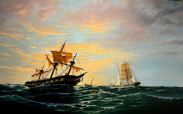
We visited the Portland Museum of Art for a few hours. Many beautiful things to see there. This one is called “After the Squall”.


And finally we had dinner at Scales, an upscale restaurant, where we scored the trifecta of oysters, crab fritters, and scallops with blueberry ice cream for dessert. A truly Maine dinner. 

And Lyft brought us back to the marina, no problems on the return leg.

Yesterday, with its short passage from Jewel Island was largely a land day, as was today. Tomorrow we return to the sea and in the evening, tentatively selected Pemaquid Harbor, in John’s Bay, where we have never been before, as our destination. 

Our neighbors here- working boats, in early morning light that caused me to think of Hopper.


Wednesday, July 19, 2023

July 19 — Day 12 — Jewell Island to South Freeport on the Harraseeket River — 8 NM

 Lifting anchor after 9 AM, after a leisurely, blueberry, pancake breakfast, there was no wind, and hence we did not put up any sails at all. The interest, during the short journey, came from 2) observing the extent to which the tidal flows changed our speed, at constant rpms, as we passed between and among islands, and 2) teaching Lene how to tell the direction of tidal flow from the wake left as the current passes lobster pot floats. 

We are on a mooring at Brewers Marina, where we have always stayed when here before. A couple of years ago I had reported that Brewers, the big fish in the Marina world, which had “rolled up”, i.e., bought out, many other marinas throughout the Northeast and renamed them Brewers, had itself been rolled up by an even bigger fish, SafeHarbor. Well that was not quite accurate. This Harraseeket Brewers was Mr. Brewers’ first marina and when he sold all the others to SafeHarbor he kept this one. It is still a Brewers. 

And a great place. For one thing, a mooring is only $40 per night. Another: “No we don’t need your credit card to reserve; just promise to let us know if your plans change and you can’t make it.” Also, “No, don’t pay us until you are leaving.” A good shower and laundry at $3.50 to wash and dry a load are appreciated as well — and used. But what really blew us away was when we asked about an Uber to get in to Freeport for shopping at LL Beans: “Take our truck; just be sure to bring it back by 5:30 so I can get home tonight.”

We had tried to rent a car for the two days we will be here in So. Freeport and in Portland, perhaps easier than taking so many Uber rides. But those willing to rent were not willing to pickup and deliver, requiring Uber and thus defeating the purpose of the rental. So the Marina’s truck was a Wow!

We bought several things at LL Bean’s and other outlet stores and at the local supermarket. Then out first Maine Lobster of the cruise: lobster rolls. I’d always though us them as a lot of mayo with bits of lobster meat on a hot dog bun for $25. But while Harraseeket’s had all the ingredients, the proportion was quite different: mostly huge chunks of lobsters and delicious. And to end the day as it began, blueberrys again, this time in a pie with ice cream. Life is good.

July 18— Day 11 — Isles of Shoals NH to Jewel Is. ME — 50 NM

Underway  8:20 to 4:20 — eight hours. And it was foggy, estimated visibility 100 yards to 1/8 of a mile; it varies with lighter and heavier patches. Except for the first and last fifteen minutes we did not see a thing: not man nor beast nor boat nor land. We did “see” a few other boats on AIS, and we had radar on and checked it frequently. We did avoid both rain and thunderstorms, which had been forecast, but fog sailing is an anxious strain. —  scanning the horizon constantly, hoping that no other boat is headed toward us like the destroyer that cut JFK’s PT-109 in half and the nearby water, hoping that we can spot and swerve to avoid toggled lobster trap floats. Neither of us wants to be responsible for a calamity due to inattentiveness on watch. We stood watch for alternate hours (the schedule suggested by my mate) while Auto did the real work. With wind behind and not strong, we motorsailed.


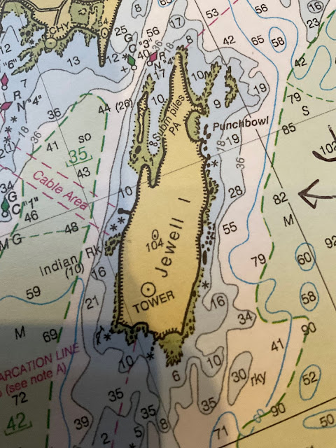
Jewel Island is a lovely spot. The anchorage is the crevice, about 3/10th of a mile long, on the NW side, with room for perhaps a dozen boats, though only half that many this foggy weekday night. The south end has a bar that even at high tide will break southern waves like those expected tonight.


The northern end, through which boats enter, is open to the north winds.

I measure the entire island as 1.1 miles long by .3 miles wide at its widest point. Our first anchor drop put us too near the western side so we tried again. And the windlass got stuck at one point so I lifted the anchor by hand. I do not know why it got stuck. It worked later and we are in ten feet of water at low tide with 40 feet of snubbed chain. I was amazed at my strength in lifting the Rocna by hand.

We have been here many times with guests; Jewel has no commercial activity of any kind but rugged natural campsites with rugged toilettes for the environment, trails and lovely features. The “punch bowl”, where horizontal layers of rock crashed forming the vertical sides of, well, a punch bowl. An abandoned WWII tower from which our armed forces tried to sight potential submarine entries; yeah, right, we were out in fog today and the tower seems like folly. But we are tired and did not even lower the dink tonight. The trails are footpaths and if you get lost, keep going and you will come to the water’s edge.

July 17 — Day Ten — Manchester MA to Isles of Shoals NH — 38NM

First an apology for any readers who expected more prompt posting and worried about us. The culprit has been lack of internet and it may get worse. I have some photos I’d like to share with you but may have to edit this and other posts later when internet is more available. 

We were underway from 8:00 am to 1:20 pm, 5.33 hours, mooring to mooring. But motoring all the way,  because the wind was directly behind us, too light, so while we put out the main with preventer and Genoa they did no good and we furled and continued motoring — and rolling as happens on a dead run. The distance is from the tracking feature of the chart plotter. It’s funny, because I laid out a course on paper charts that included a shortcut (behind Thacher lsland, that we did not take because of the wind and fog). So the “long cut” we took should have longer, not shorter. Another mystery of the sea. 

The fog off the Cape, gave interesting pictures of the tops of the two lighthouses.


Once past some junk off the tip of Cape Ann, it was a straight shot to White Island, at the SW corner of the Shoals with its lighthouse, seen over Lene’s right shoulder during our ramble over the wild southeastern part of the island.


Auto performed perfectly while Lene maintained the watch during which 
I got a chance to clean ILENE’s heads and interior and we showered.


The shoals are a delightful favorite on the Maine-New Hampshire border but six miles off shore. It is a convenient stop (though not midway) between the Cape Ann MA ports  and Casco Bay ME ports. And it has free moorings, courtesy of the Portsmouth YC, if you can get one, which we somehow always seem to be able to do, including this time.


The largest island in the group of tiny ones is Star Is. Which has a large old hotel that books week long spiritual retreats for groups that come out by ferry from Portsmouth. It started and remains partly as asset of the Unitarian Universalist church and shrines and monuments are situated in various places. This year a large new solar paneI field and a placard memorializing the female slave owned by the founding minister. The hotel has a huge “Mess Hall” style dining room for up to 300 guests. Boaters like us are permitted to roam the island after landing our dinks, but must be off the island by 5 pm, so are not able to buy dinner at the hotel; we have plenty of food.

 We hiked the rugged bird covered rocks, pounded by the ocean.


There is a monthly column in Points East magazine written by the Captain of the ferry, who also does maintenance projects here, especially in the winter. I thought of him because there is a maintenance project noisily clanging here with bucket loaders moving boulders to repair and reinforce the seawall between Star Island and neighboring  Island, a bit of which appears to the left. But first, a view of the back end of the hotel between a monument and Lene. 


The seawall creates the harbor. But the noisy operation ended at night, leaving only the gongs created by the movement of the buoys.


Tomorrow: on to Casco Bay— Maine proper.


Sunday, July 16, 2023

July 16 — Day Nine — Lay Day in Manchester — Well Boston Actually

With the weather threatening (I heard the words “hurricane” and “tornado” bandied about) and in any event lousy with all-day rain, and with the cheerful willingness of our friends and their Club to put up with us, we elected to stay on the mooring they gave us for another night, and travel into Boston to visit the JFK Presidential Library on the U. Mass campus in Dorchester, on the waterfront.  We had walked past it from the Savon Hill YC, during our last cruise in Boston. But then, due to Covid, it was closed. Our excursion was fun, involving 1)  the Club’s launch to the town dock, 2) a commuter rail line trip into Boston’s North Station, 3) two trains of the MBTA and 4) a free shuttle bus to the Museum.


JFK’s favorite boat, “Victura”, a fifteen foot gaffed rigged wooden sloop, is on the grounds.

The Museum celebrates everything Kennedy, with one exception. I saw it as a fair review of the inspirational leadership of our witty, charming, articulate, well educated, cultured, idealistic, young President. In the part describing the diplomatic v. military strategies for dealing with the Cuban Missile Crisis of 1962 (an embargo was selected as a middle course) it skipped around the disastrous failure of the private mercenary Bay of Pigs invasion of Cuba which our CIA financed during JFK’s three years in office. But that invasion to overthrow Castro took place in April 1961, only three months after JFK’s inauguration, so I therefore believe it was planned by the Eisenhower administration. It was seen as a cause of Castro’s seeking military assistance from Russia, a cause of the missile crisis.


The only criticism of any Kennedy was contained in a special temporary exhibit devoted to WWII in the poster above. It described JFK’s father, Joseph Kennedy, who had served President Franklin Roosevelt in several important high level capacities, the last of them as a terrible ambassador to England in 1938 — he sought to appease Hitler and cost our nation the respect of the English people.  Elsewhere the museum described the two books that JFK wrote. One featured domestic policy — “Profiles in Courage”, celebrating several US senators who took courageous stands for the benefit of our Nation against popular but evil measures supported by their own party in Congress; we sure could use some of those now. The other involved foreign policy and defense issues —  “Why England Slept” which explored England’s failure to rearm after WWI when it was clear that Germany was doing so. I had never before thought of the latter book as perhaps JFK’s criticism of his Father. Or am I getting too psychological.

Lite lunch in the museum’s Cafe and salad and pizza  in Manchester before the launch retrieved us in the rain.