"There is nothing more pleasant than cruising on a boat with the whole family."
Letter from Empress Catherine the Great

Friday, August 25, 2023

August 24 — Day 46 — Long Cove to Round Pond — 19 NM


First: two views of ILENE on a mooring in Round Pond, which is much smaller than Long Cove. Measured by by dividers on the charts, the Cove’s useful deep enough water is roughly .3 NM by .5 NM. In Round Pond, the mooring field’s useful circular (hence Round Pond) area has a diameter of only .2 NM. Our journey, four hours, was all with engine, though we were able to get a few tenths of a knot from the small jib on the westbound part of it, the  crossing of Muscongus Bay. 

Our first problem this morning was that a part of functionality in the chart plotter was inoperative. Normally two lines are projected from the bow of the image of the boat on the screen. The blue one shows which way we are going from moment to moment and the purple one sort of averages out the jerky motion of the blue one. Once on course the two lines get closer together. When rolling, the GPS receiver, at the top of the mast, 63.5 feet above sea level, waves madly  and the blue line goes from one side to the other, every two seconds or less. The purple reflects the actual course. But in a turn, we know which way we are going frim the Blue line. This morning no blue line. It is not needed but useful. Raymarine’s tech rep staff’s phone number is in my cell phone and a call and the pressing of three buttons as advised restored the blue line. The only remaining mystery is how I had accidentally turned it off.

The exciting part, but not really, was in Davis Strait, which was not as narrow as it seemed. We passed and  rounded many islands and shoals including Old Hump Ledge:


The tiny black dots on top are the birds whose excrement turned the rocks below them white— sort of like The Blauses off Hart Island at home.

We got in a two mile round trip walk to where we thought the man who rented us our mooring was; he later came by The Anchor, where we had dinner. There are also two competing lobster pounds in town, an antiques shop, a variety store and a post office. Tomorrow looks like rain and if so we will get wet. Early reports of Tropical Storm Franklin add a bit of anxiety into next week’s plans; hopefully it will blow out to sea or only dump some rain on us.

Wednesday, August 23, 2023

August 23 — Day 45 — Castine to Long Cove — 33 NM

 Today was poorly done — by me — though not dangerous and all hands — and paws — are safe. It was the negative side of cruising. Bet you never thought you would ever hear me admit that there even is a downside to cruising. But even with the luxury of what will be approximately a two month cruise, our days aboard are finite and we had to go today. We committed the cardinal sin of agreeing to meet friends on future dates. We made matters worse by a delicious breakfast in Belfast and hence did not get underway until 10:05, after the favorable tide had ebbed away leaving us adverse flooding tidal current during virtually the entire six hours and twenty minutes of the passage. Our route took us from the north end of Penobscot Bay, along its west side, to its south end - homeward. We passed Camden, Rockport and Rockland, all great ports we have visited before. I had elected the short logical route, through the Owls Head and Muscle Ridge Passages which wend their way among islands off the shore. We have travelled that route both north and south on prior cruises. Here is Owls Head Light.

We passed several more of the schooners; perhaps a dozen of them operate out of Camden taking tourists out for day sails or week long cruises. But they were going east or west enjoying the wind while our course was south, into it. 


The island passages we transited focused the current and the wind, which grew to 18 knots apparent, in our faces and forced us to furl our sails. The wind would have been great for sailing, with reefed main, had we been willing to tack, outside those passages, but the Admiral did not want to, and on a long passage, tacking makes it longer. Lobster pots were not prevalent in the northern part of Penobscot, the lobsters having presumably decided that the cooler ocean waters are preferable, but were abundant toward the end of the six hours.

We were headed toward Tenants Harbor which we have also visited on past cruises. It is crammed with moorings, one of which we planned to rent. They take up all of the acreage and thus prevent anchoring. It also has a few places in which one can eat. But the Cruising Guide mentioned  adjacent Long Cove, with tons of room for anchoring, in waters of the appropriate depth of eight to 13 feet and a good mud bottom for grabbing anchors. And we had never been here before and had lots of food, so… we anchored in 18 feet of water at a spot charted as eight feet at low, with sixty feet of snubbed chain. 

These pictures show first a portion of Tenants Harbor from ILENE, across a shoal barrier that separates the Harbor from the Cove, and then the vast open area in the Cove.


August 21 & 22 — Days 44 — Benjamin River to Castine to Belfast — 16NM & 10NM

 The two passages began alike in still water, and we passed a lighthouse in each. 

Pumpkin Is. light with the green buoy in the first passage and Dice Head Light among the pines on the second.  But the wind never came up during the first passage. My one attempt to unfurl the small jib lasted only a few seconds and ended in failure. On the second passage, once we had cleared the Bagaduce River, on the north shore of which rises Castine,  we cut the engine and sailed, albeit an average speed of 1.8 knots, for about an hour and a half. 

Then the wind came up and it was a fun exciting sail most of the may in to Bellfast. We had a chance to play with the schooners each filled with paying passengers out cruising from port to port.


Here in Castine are, from left to right: State of Maine (the training ship of the Maine Maritime Academy, ILENE on mooring and one of the charter schooners. She and another, ended up docked in Belfast.


In a sense, every port town is alike, with a street along the waterfront such as Water St., Front St.,, etc., and other streets perpendicular to it going up hill away from the water. Both Castine and Belfast rise steeply from sea level. They are essentially in the NE and NW corners of Penobscot Bay. And they bring out memories of our prior visits and of Bill and Sando who we first met in Castine because they recognized ILENE as a Saga, and connected with in Belfast (and many other places) in later years. We dined with them in Castine’s fine dining restaurant which was closed on the day of this visit. Hence Thai food in a quirky corner place this time.

Last time we walked in the eastern part of town and I jokingly called Castine the town with the greatest number of wooden sign posts memorializing trivial moments in 17th Century history per capita in America. A few random examples:


But the reality is that Castine has a proud, keen and active interest in its history. This time we roamed west, toward the lighthouse in the pines, but did not get that far (it was hot) and we stopped at the free admission Wilson Museum. Wilson, with his PhD from Columbia from before WWI, was an archeologist, anthropologist and collector. He purchased and lived on the island across the Bagaduce River from Castine. The museum has a thorough explanation of the various ages of Earth’s geologic eras, artifacts from native peoples from around the world, and the history of the town, the State of Maine and the Wilson family. Quirky but an interesting 45 minutes. We stopped to mail a check at the “second oldest continually operating U.S. post office in the U.S.”


We saw the newly arrived students of the freshman class of the Maritime Academy practicing at soccer and marching.

We were at a mooring right off from the tumbledown old fashioned Eaton’s Boatyard — in the family for generations.

In Belfast, Lene tripped and fell getting from the dink to the dinghy dock and the harbor master provided an ice pack, antiseptic and bandaids. After a rest in her office for half an hour while the shock of the trauma receded, we walked up the main drag. The Old Professor’s Book Store, is still there, but under new management after the death of the professor who used the store to sell off his library. We stopped at the Belfast Co-op Market for provisions and dined at waterfront Nautilus.

I’m flanked by a pair of Ilenes and Cruiser in his favorite “one foot forward” reclining pose.


Tuesday, August 22, 2023

August 20 — Day 43 — Frenchboro to Benjamin River — 19 NM

 We left Frenchboro with the Ferry taking people off the island.  After he passed us we put up main and small jib with wind in the teens from our side. Well a bit too much wind so I put a reef in the Main. We sailed almost the whole way without the engine, except when passing through Casco Passage which took us from Blue Hill Bay west into Jericho Bay. We put in two tacks to get close to Casco Passage but we could not be tacking through that passage so furled the jib and used the diesel until we were through it. After crossing Jericho, we entered Eggemoggin Reach, the northernmost internal E-W passage in the area. It is wide and straight and divides the islands to its south, mainly Deer Island, from the US mainland to its north. John Steinbeck in his last book, “Travels with Charley”, about a road trip around the US in a pickup converted into a camper with his standard French Poodle, Charley, described his visit to Deer Island, crossing the suspension bridge that we sail under each time. In the Reach the wind dropped to less than ten knots and our speed was no longer more than seven knots, but half that. Lene likes to go that speed. Serenity. The Reach is a favorite with us because of Bucks Harbor at its western end, but a main attraction there is its restaurant, which was closed on Sunday. But the Cruising Guide mentioned Benjamin River, a big fifty foot deep hole cut into the north side of The Reach, guarded by a significant shoal that blocks off most of the entrance, except at the extreme right in this photo.


It is rimmed by moorings near its edges, where the water is less deep. With our 300 feet of chain, we could have anchored with 150 feet of chain in the vacant center with plenty of swing room. But I did not think of that (nor did the Cruising Guide suggest it) until the morning. We took a rental mooring. The only attraction ashore is a market 2.6 miles away and we did not relish a round trip hike of that duration so we did not even lower the dink.


Our neighbor was Grayling, a beautifully restored former sardine transporter. In the morning the mooring rental operator came by to collect his fee. We had been unable to raise him on Sunday.

Monday, August 21, 2023

Aug 19. — Day 42 — Northeast Harbor to Frenchboro, Long Island — 12NM

 We slipped our lines at noon for the 3.5 hour passage to one of my favorites, but it was a tough and dangerous passage. I should have paid more attention to the wind speed and direction instead of blogging. The wind was at 17 knots true, on our nose, requiring tacking out through The Western Way, which is the N-S Avenue out of the south side of the Mount Desert Island archipelago. Yes, Long Island is south, but actually it is SSW, where the wind was coming from. Also, I had failed to put in a reef. Flying by the seat of one’s pants is dangerous. We got out past the reefs at both sides of the Western Way and a couple of miles more and then we hit a lobster pot float. Our speed slowed from six knots to two, gradually, as we towed a crate along the bottom.  I had to act fast lest we get dragged across another of the ubiquitous lobster pot floats. We furled the jib and then dropped the main. But the second of those two moves should be gone while facing into the wind. In this case with the stern anchor provided by the crate, our stern was facing the wind. It was a struggle to pull down the sail while standing on the coach roof in ocean swells maxing at six feet in hight. Then the plan, risky, was to try the Yanmar, but if the lobster rope is caught on the prop, this could damage the prop and the hull and choke off the engine. The alternative of donning wet suit, lowering the dink so I could get back in, tying a line around my waist and jumping in with knife to cut the rope was not appealing. I imagined getting a concussion when ILENE came off a high wave and crushed me as it fell the five feet. So the acid test: put the boat in forward and let’s see what happens. (Fortunately we were far away from reefs as we drifted.) Well we started moving forward and then immediately made two 360 degree turns, a figure eight as it were. And we were free at last, and motored with high rpm’s but slowly because our speed was broken by the waves and wind on our bow, the last five miles to Frenchboro. During those miles a super vigilance against lobster pot floats was maintained. The height and force of the seas dragged the floats temporarily under water. And we listened for the bilge pump. It comes on for a half a second every two minutes even when the bilge is dry to test that condition. If more regularly, or for longer duration it would mean a hole in the bottom through which water was rushing.  No pictures of the excitement.

Once on a mooring in Frenchboro, the day brightened markedly. We walked to the library which has resumed its former practice of remaining open 24/7 on the honor system (they trust us not to steal stuff) with good Wi-Fi. I got the prior posts posted.


We had lobsters with butter, lemon, cole slaw and corn on the cob at Lunt’s Deli.  ($35) I had a hankering for a slice of their homemade blueberry pie made with the small local blueberries, but I was full. Here is Davida, our chef, bringing  our lobsters up from the sea, ILENE’s hull visible at the top.
Their shells were rust colored, not bright pink; very rare.
Next: our dinghy at the dock, ILENE at the far left and the tall mountains of Mount Desert Island in the background to the right.


The night was the least calm of those we have experienced so far on this cruise. A bit of the big waves crept in and rocked us a bit because we were moored north the the ”L” in “Lunt’s Harbor” on this hand painted billboard map of the island.

Saturday, August 19, 2023

Aug 17-18 — Days 40 & 41— Eastern Bay to Little Cranberry Is. to Northeast Harbor — 36

 Before I get started, I neglected to mention a significant event occurred in the Eastern Bay anchorage. My Communications Officer called US  Customs and Border Protection to let them know we were coming ashore at Mt Desert Island and would stay aboard under quarantine until they could come inspect us. But there has been a change of methods.  Now there is an app, CBP ROAM. One has to download it and load  all your info on it. Lene spent an hour trying over and over to get this done with multiple passwords and authentication devices. If alone, I would have given up, claimed “asylum seeker” status and become a “man without a country” for a while. Thank God for Lene! They wanted us to photograph our passports into the system as well. Then a reply to the effect:  we are considering your application and will get back to you. Half an hour later an email: “You are approved.” No need to to go to an official port of entry. So the new system is both harder (for non IT people like me) and easier. We were back in the USA, both physically and legally.

The first of the two passages in this post was rather unpleasant, despite sightings of a finback whale, a pod of dolphins and a grey seal. There was zero wind so the seas were flat, making the wildlife more visible. It was cold and grey, with drizzle and, being back in Maine, lots of toggled lobster pot floats to dodge. I crossed one of them and realized it, too late, when the toggle was being drawn to the boat by our keel or rudder. I immediately shifted neutral to avoid getting the line wrapped around the prop, and then turned sharply and hoped the line would drop off, which it did. Another anxiety problem was that we did not have a reservation and rain was forecast for the next day. My Communication Officer had calls in at three places as we headed toward the point where we would have to head North to Northeast Harbor, continue west to Southwest Harbor, or turn south into the anchorage between Big and Little Cranberry Islands. Finally the Islesboro Dock Restaurant by the ferry landingon Little Cranberry got back and said we could have (A) one of three free town moorings far from them or (B) their own mooring near their dinghy dock for $40. We took option B, what with the fog growing thick, lowered the dink, somewhat dried the seating area of the dink with the chamois cloth and dinked in for dinner at the restaurant. No internet or Wi-Fi. A cold rainy night but warm and dry in our snug home.

Next day was mostly a work day. The Harbor Master of Northeast Harbor, on the mainland of MDI, said there would be moorings or off-shore floating docks available, but no reservations — call when in the harbor. We stopped at Clifton’s Fuel Dock in the Harbor (where we waited several hours for CPB to show up when checking in from Nova Scotia in 2017) to refill both water tanks and fuel tanks. Once on a floating dock, we went for lunch, grocery shopping, laundry and showers. Then cleaned the boat interior. So Lene had all she wanted: full fuel, water and food, clean laundry and a clean boat. 

I plotted out the first very rough draft of our itinerary from here to Block Island with a target date of September 10, leaving five days to get home from there (though we could do it on one overnight sail)  and room for slippage due to bad weather days before then. It includes lay days in Boston, Hyannisport and Martha’s Vineyard in case friends are available when we come through.

A few boats away I spotted ”Fika”, the Saga 43 shape so easily identified. We later met John and Susan and their crew, Jackson snd Bosn, English Cream Goldens. A Fica is a sort of Scandinavian coffee klatch with food, an act of hospitality, Susan told me.The Cumberland home port is in Maine, not Maryland. Fika is a few years newer than ILENE, and our new friends have sailed her the last three years.

The remaining picture,  like those above, were taken by Lene on the sunny morning of our departure. 

August 14 - 16 — Days 37 - 39 — Digby NS to Grand Manan Island, Lay Day and Back To The USA — 48 & 44

 We left Digby with a nice slack tide in the Gut, the only problem being the ferry at the dock which we passed. I tried to be a good citizen by calling to ask if we should wait for her to go out or go out ahead of her. The answer was that she would leave in five or ten minutes so we hurried to get past her, but then she stayed for 20 minutes — annoying.


 We put up sails once through the rough spot in the Gut. Fog became a recurring visitor, as it did on the second passage in this report, occasionally very dense, sometimes better, with up to half a mile of visibility, and other times totally absent.

Again in good periods we were making seven knots with Main and jib, other times less. From hearing the ferry’s fog horn when she came out behind us headed to Saint John and “seeing” two fishing boats headed south along the coast of Nova Scotia, but only on AIS — no boats til a mile off Grand Manan.

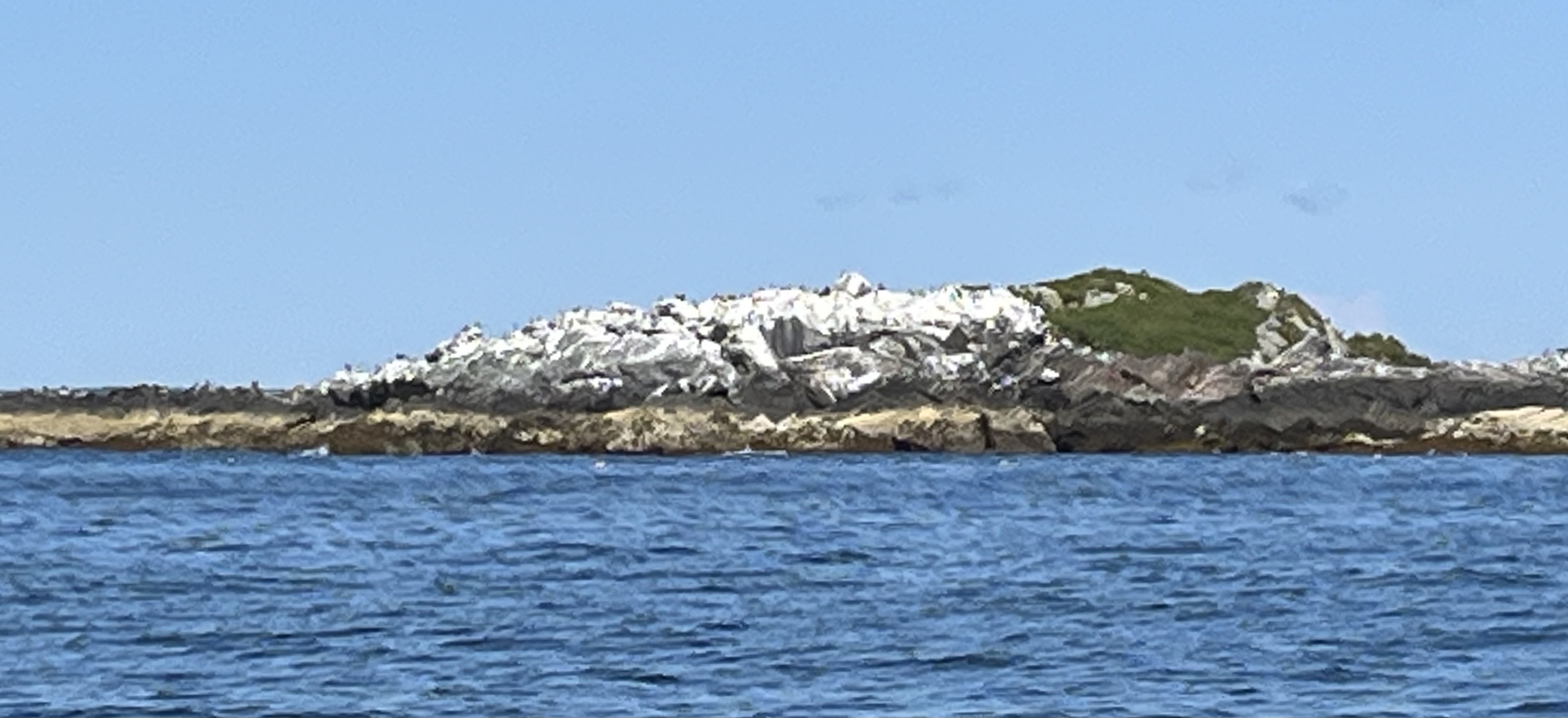
Grand Manan, I always thought was a French name but I was only half right; it means Big Island, with only the first word from French, the second being a contraction of the Native American word for island, Mananuk. It is about 13 miles long and much closer to the Maine side of Fundy than the Nova Scotian side.  So the shipping separation lanes to Saint John,  each a mile wide and separated by a mile wide “median strip”, were crossed during our passage to Grand Manan. These lanes are designed to prevent collisions between incoming and outgoing freighters. We crossed the northbound lane in deep fog and the southbound in clear sunlight. The former was not very scary because such “big boys” transmit AIS and would show up big on our radar. This is the west coast of the big island from eight miles out. As we got closer we could see a lot of the coast of Maine and New Brunswick at its sides.

We were told to take any available yellow mooring in North Cove and there were several of them, and free. Fortunately, the strong winds, which later died out, were from the west so the island blocked the big waves. The blue-green boats in the next pic are in the employ of the nearby fish farming operations. The huge ferry dock is off screen to the left. Behind the crane on the raft in the foreground, you can just barely see a blue sailboat, which will come into this narrative later.


The lay day was not a very good one. Our hike to the north end was marred by a steady drizzle which also prevented the vistas from the island’s heights and by boggy trails through campgrounds with lovely big tents and living areas covered by suspended tarps that families had set up. Swallowtail Light House was mostly oconcealed by scaffolding to permit its resurfacing.
Then a long walk south for milk and bread, a mediocre lunch out and,
 after depositing Lene aboard I went in to fill three empty one gallon fresh water bottles. No water at the dock so I walked to the ferry office to use the sink in their men’s room. But a sign said “not potable.” What to do? The ladies in the office said to fill from the five gallon bottled water fountain. “Three gallons?” I asked. Yes was the reply but it ran dry after 2.5 and I was not about to complain. We have plenty, now. 
But then the problem happened which provided opportunities for so many people to help me. All sailors love helping other sailors; for me, less so being the recipient of help. But I got a lot of help from many people in North Cove.


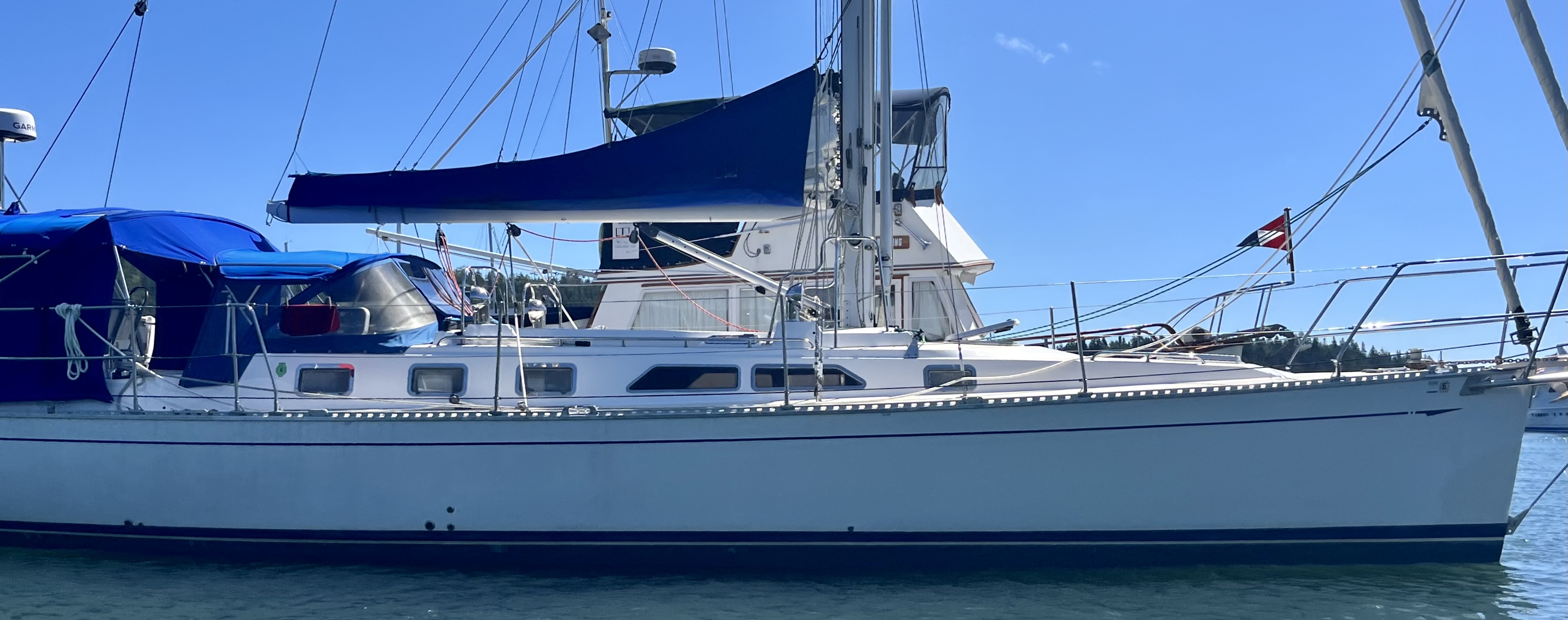
The dinghy outboard would not start. We do not have oars, just canoe paddles, which work if Lene is with me, but are very inefficient when alone. I hailed Mark of the beautiful light blue 47 foot Cambria sloop mentioned above, “Spirit of Tobomory” out of Toronto. I asked to use his tools, which he provided. He was rafted against an out of season fishing boat tied to the high concrete fishing dock. Mark provided tools but in the process of my adjusting things the spring sprung off, out and into the 30 foot deep frigid water. Now our only hope was a mechanic. Mark called Lene for me so she should not worry. He allowed me to photo the mechanism and sent the pics to Lene’s phone. A retired gentleman named George, watching from the fixed concrete dock high above, said he knew a great local Yamaha mechanic but could not recall his name or number. He offered to take me there in his truck. But it was blocked by two tractor trailers, one behind the other, on one side of the broad pier and two cranes on the other side, waiting to take the load, high sided four foot wide canvas bags of fish food for the nearby aquaculture factory farming operation onto the boat to take them there. But the boat was not there yet. Amazingly the drivers moved their trucks to free George’s pickup. He took me to the place he knew, but the secretary there said that Darryl (his phone is 506-662-3361 should you need such services) had left for the day but gave me his number to call in the morning. George drove me back. I got back on the dink and prepared to paddle out perhaps 150 yards to ILENE. But an aquafarming work boat was passing by and when hailed, towed me in the dink out to ILENE. I had a poor night’s sleep over anxiety about the next day. 
We had previously asked George and a companion about the tides if we want to leave that day, and learned that 11 am was the time to leave (noon if we stayed another day).

 The activities offered at Grand Manan, in addition to hiking (some long trails but they expect us to drive to and from the trailheads),  electric bikes and whale watching tours. None of these had great appeal for us. There is an arts scene, but not for those without motor vehicles.

So Grand Manan provided less for us than we had  expected.

We called Mark and he said we could raft up ILENE to his boat, but he planned to leave at 10:30.

We called Darryl who came ou to the dock while we moved our boat to it. He did not have the spring, which would have to be ordered, but explained that the mechanism involving the spring is designed to idiot proof the outboard to prevent people from starting it while in gear. He removed and gave me a part to be saved and reinstalled with the spring this fall. We tested the outboard and it works. He also taught me about the air valve on the gas tank and suggested a way to prevent water seeping into the squeeze bulb primer. He asked for $40 Canadian, worth $30US. We thanked him profusely and were off.

Here is “Spirit of Tobermory” on the way out.


The two passages from Digby to Maine represent our third crossing of the Bay of Fundy. The first was in 2017, across its mouth, from the southern tip of Nova Scotia to Mt. Desert Island on return from our cruise  that summer. The second was from St. John to Digby across its northern end. This time it was a diagonal SWcourse leading back to Maine. The bold cliffs of the north and west sides of Grand Manan were obscured by fog at the beginning, but came into view.


The tide was wrong at first; we were too early. But as adverse tide slowed and was replaced by more favorable tide out speed picked up. We used Main and Genoa and turned off the diesel. The wind got lighter and we slowed gradually, to less than four knots before we furled and motored. We started with two alternative potential destinations in mind. Cutler, where we stoped while outbound was nearest. Roque Island came next, a favorite, but not this year. We went further to a “new” anchorage (for us) in Eastern Bay by Great Wass Island. Very close to The  Cow Yard, where we stayed on the way out.
The green line I drew on at the right shows our route to and from The Cow Yard. The red line, north through narrow straight and clear Main Channel Way, is how we went in.  A high pink smooth marble wall to starboard. Most of the area north of us in the cove where we anchored, is filled with a commercial fish farm, seen only in silhouette in the pretty, untouched sunset picture. And for our way out next day we plan to exit through wide but rock strewn Mud Hole Channel, further west. Here are views from ILENE on anchor with  60 feet of snubbed chain in 20 feet of water.


Oh, and here is our boxed set: