"There is nothing more pleasant than cruising on a boat with the whole family."
Letter from Empress Catherine the Great

Thursday, August 29, 2013

August 29 -- Marblehead to Cohaset

We were nearer the mouth of Marblehead Harbor and that may have contributed to the rollyness at our mooring all night. It was not a calm night and the humidity was intense in the fog, which continued through most of the night. It was like living in a cloud. Actually, we were living in a cloud. Lene opened the hatch over our bed with the result that the wind blew the fog through the screen which caught it and caused it to condense and drip onto the bed. And in the middle of the night a big crash. But it did not wake me. Lene did wake, however, to report that the percolator,awaiting the morning with six cups of water and the corresponding amount of ground coffee had fallen off the counter onto the rug in the galley, making a mess and breaking the new plastic see through insert at the top of the pot. Mess cleaned up and remaining part of plastic top placed into service with duct tape. No problem.
We got underway at 8:30 and once we cleared the neck we had a straight shot for the entrance to Cohasset, and averaged 6.8 knots with 10 to 15 knots of apparent wind off our port quarter, heading about 185 magnetic under main and small jib.When we had approached Marblehead, we had been able to see the skyscrapers of the Boston skyline; not today though we were much closer to Boston.
We had the opportunity to use our new app, Ship Finder. This monster was off our starboard bow as soon as we got on course, headed across our bow. This shot shows her after we got much closer and were clearly safe. Ship Finder told us that she was registered in the Marshall Islands as "Noreaster", 594 feet long, 96 wide, and drawing 38 feet. But most important it said she was making zero knots, in other words, anchored. Here is the view the toy gave us of this, after we had passed her, including the white line reflecting the loops Noreaster had made before anchoring. The blue dot is us on our way south from Marblehead at the top of the screen.
Cohasset is a tight little harbor entered through a shallow channel via one of three routes. We took the eastern way and between good enough visibility to see the buoys and Lene reading off from her iPad, it was easy, though a bit scary when passing close by visible rocks and with only two feet of water under our keel.
Cohasset has a pretty, traditionally New England style Village Green,


with the church at which they filmed the Witches of Eastwick, currently undergoing renovation.


The town also has a small and not very well organized history museum. Interestingly, it said that the men of Cohasset had scared off the British after they had bombed neighboring Scituate, where we had stopped on our way north in June. Readers of this blog will recall that in Scituate the claim is made that the two daughters of the lighthouse keeper scared the British away by playing the fife and drum, saving that town.
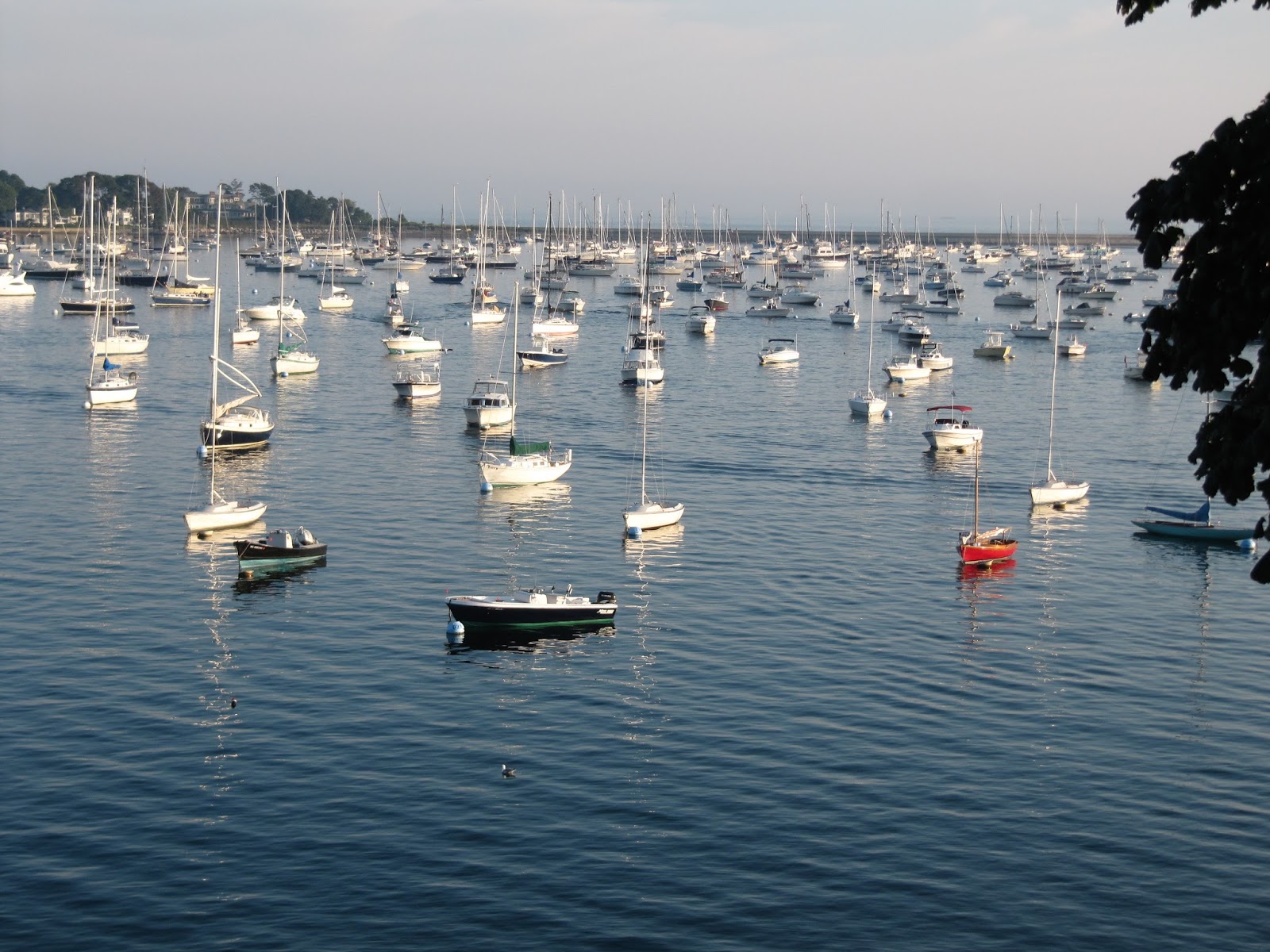
 Ilene had a surprise in store for me. When we walked into town from the dinghy dock, we passed the Cohasset Harbor Inn. She got the idea to spend a night off the boat, our first since June 10. And once she gets an idea in her head, there is no stopping her. Here is the view from our window with Rojay, our dink, furthest right at the dinghy dock in the lower left and ILENE's mast the tallest in the inner harbor, center.
We dined ashore after putting out lots of cat food for the crew, at the tapas place in the hotel. Pretty good except the alleged flan, while tasty, was a chocolate mouse!

Wednesday, August 28, 2013

August 27 -- Gloucester to Marblehead and Lay Day There

What a difference a day and twelve miles makes! Gloucester is a commercial fishing city while Marblehead is crammed with moorings mostly with sailboats of pleasure; there is a forest of masts here.
We motored in light wind, supplementing with the genoa for about 40 of the 120 minutes, which gave us a knot.


Along the way we saw some rather large houses,


a lobsterman with hungry avian friends,


 Bakers Island Light,


and Marblehead Light.


We took a mooring at the Boston YC here. It is a bit more posh than the Harlem but the food is not as good. 500 members!

After lunch aboard we took the sleek Hinckley launch to go ashore and explore, as is our habit. But when Lene learned that they have a movie theater that was showing Blue Jasmine, we had separate afternoons.
The houses here have the names and professions of their builders and the year of construction as is true of many New England towns.


I visited Abbot Hall, which is the City Hall but also has a history museum in it.


Here is its tower, visible from the sea. From a distance, I had thought it was a church steeple. 


It features famous native sons of Marblehead: Four seamen who fought bravely for our nation and were honored by a series of warships being named after them, the most famous being John Glover, who ferried General Washington's troops from Brooklyn to Manhattan, thereby saving the Continental Army, and who later ferried General Washington and a few troops across the Delaware for that surprise raid on the Hessian troops there.

His boyhood home still stands.
Because the first four ships of General Washington's Navy were captained by Marblehead men, the town claims to be the "birthplace of the navy".They also featured the three cruisers that bore the name USS Marblehead. Mr. Justice Story, appointed to the Supreme Court at age 32 and who served for more than 30 years in the court's early days was a Marblehead man as was Governor, Vice President and Declaration of Independence signer Elbridge Gerry, who is more famous, or should I say infamous, for inventing "Gerry-mandered" congressional districts.Here is Gerry's warehouse


and his home.

I also visited the Marblehead Museum and Historical Society, which had an exhibition on the town's contribution in the Civil War.
After, I bought a clevis pin at Westmarine, to replace the one that went overboard (which held one end of the aft lifeline) we reconnected and visited Crocker Park, next to the YC, with its magnificent views of the harbor, left, center and right. ILENE is toward the left photo, with the lighthouse, but I cannot pick her out. We caught this at tide change because the left photo shows the boats pointing one way and the other photos show them facing the other way.


Before our planned departure for Cohasset we explored again in the morning. It was foggy but we hoped the fog would burn off.
It got worse, though you can still see neighboring boats, though just barely, if you look closely at the photo below. We took off but after a few minutes the Admiral prevailed upon me to return to an empty mooring, this one of the Eastern YC. We called them after we got moored and told them that we had taken one of their moorings.

So this has been an unplanned lay day.


Here is the Old Town House, a public meeting hall since 1727.


Fort Sewall, now a park, was built of earth at the entrance to the harbor in 1742 as protection against the French, but used to protect Old Ironsides which took shelter under her guns in 1814.
We have reconfigured our remaining itinerary AGAIN!  Previously we had nixed going to Nantucket via the outside route, in the Atlantic, from Provincetown around Cape Cod. Seventy plus miles was too long a trip for one day, decided my previously fearless admiral.  Today she decided we would forego the four Nantucket days entirely: it is one day east from Martha’s Vineyard, two days on the island and one day back. I think it was the one day east, away from home, at this stage of the summer, that did it for Ilene. We visited there back in the late 90’s and will visit Nantucket again, but not in 2013. This gives us more time to explore new places on the western side of Cape Cod Bay (currently Cohasset and Plymouth are planned) and in the Martha’s Vineyard region as well. We learned that Bennett and his wife Harriett are planning to visit Cape Cod so I have been figuring when and where we could meet them and this fog delay has removed some options.

Tuesday, August 27, 2013

August 25 and 26 - Isles of Shoals to Gloucester and Lay Day There

The 31.4 miles took 4.5 hours after our 9 am departure. Like yesterday, there was no wind.Generally, blue cloudless skies mean no wind. I think I got a sense of what it feels like to be a power boater during this passage. They prefer no wind because it makes a smoother, waveless ride. For us, the joy is normally in the journey, but with no wind we just wanted to get there as soon as possible so we pumped up the revolutions per minute and made seven boring knots per hour while burning more diesel fuel than we wish to. It was quite a straight shot on the auto pilot from Isles of Shoals Light to Cape Ann. Then, along the coast of Cape Ann we saw these huge windmills, but they were still, not earning any kilowatts today -- no wind.
What they really need to develop instead of wind turbines, is how to generate electricity from tidal flow; The tide flows every day.


 We passed Eastern Point Light, guarding the entrance to Gloucester at the southern corner of Cape Ann.


From here it is another two miles into the inner harbor, passing the cute little Tenpound Island Light inside the harbor. I read that a few years ago Bill Gates purchased a painting by Winslow Homer of this light.
The huge outer harbor is created by a man made seawall from Eastern Point Light.


But we are moored off Brown's Shipyard in the much more dense inner harbor, next to these fishing boats.
Note the windmill, over the town.

This is a fishing town, not a sailing town. Sebastian Junger's book, The Perfect Storm is set here. Mark Kurlansky, author of Salt, Cod, and The Big Oyster, wrote a book about Glooucester, The Town That Refused To Die.


The historic town proper is off the northern spur of this inner harbor, less than a quarter mile away, with warehouses at the water's edge.


Here are other views from our mooring - we are certainly centrally located.
Brown's marina

Furthest end of the northern spur of the inner harbor

Looking into Smiths Cove at Rocky Neck

The exit from the inner to the outer harbor
Before dining out, we explored the old town, its galleries , restaurants and churches including the Sargent - Murray - Gilbert House, built by John and Judith (Sargent) Stevens in the mid 18th century. (Photo is after the views from ILENE.)This is the back entrance to the house from Middle Street, by which we came upon it.
It fronts on Front Street, which was on the water when the house was built but is now called Main Street, after landfill created two more blocks of city at the expense of the inner harbor.We had an excellent excited docent who explained the several famous people who lived here. Judith Sargent was an early feminist -- not a suffragette, but seeking for women to be educated and informed of the family's finances for example. John Singer Sargent, the painter , also lived here as did the Reverend John Murray, who got kicked out of their colony by the Puritans and founded the Unitarian Universalist church here in Gloucester. And a Governor Winthrop also was in this house. Here is the front of the house, set high above what had been the waterfront street.
We perused a book store and I noticed two books, one fiction and the other not, about Dogown, a village on the Cape Ann Peninsula. I noticed an apparently much higher percentage of the books on its shelves were authored by women as compared to that percentage at Barnes and Noble.
During the night we did have some wind and a few minutes of rain but it was otherwise peaceful. And a light rain fell for half an hour this morning. Worse had been predicted.
In the morning we did the laundry and borrowed the car of Brown's Marina's manager, Valerie, to get groceries. After lunch we explored Rocky Neck, an old yet still functioning artists community, sticking out into the harbor to form Smith's Cove. First a large juried art exhibition in the North Shore Arts Association, a big red barn on the outside, which opened in 1923, near the laundromat. Then we walked around Smith Cove to Rocky Neck. On the way we stumbled into Vintage, a used clothing place, and Lene got these Frye boots for $30.00, quite a bargain she believes.

I almost got a pair of Bruno Magli shoes, as if I care about labels, but they were half a size too small for me. We ended up at the far end of the neck and Lene's legs were giving out on her so I left her there, walked back the 3/4 mile around Smiths Cove to the dink, and drove the 150 yards across the cove to pick her up.

A quiet night aboard. I did some plotting to figure out the tides for our passage through the Cape Cod Canal.

Sunday, August 25, 2013

August 24 -- Cape Porpoise to Isles of Shoals

The insects were mostly gone in the morning. This shows the passage out of Cape Porpoise Harbor, the green squares to the right and the red pointy tops to the left.
The channel is only about half a mile long and the harbor looks big at high tide with water on both sides, but at low tide it is quite narrow, about ½ mile long and 1/10th mile wide.


Here is the look inward from our mooring near the exit.
We decided to depart in the morning, 9:30 am, rather than in the afternoon, when the tide would be fair, for two reasons (in addition to the fact that the tidal flow is less here than further northeast). First, 10 to 15 knots of favorable wind were forecast in the morning, dropping to five knots in the afternoon. But in reality there was no wind in the morning or the afternoon so we motored the whole 23.9 miles, with the main up, solely to dampen the rolling. Second, this being a nice sunny summer weekend, we expected the place to be crowded, and it was, but we took one of the few remaining moorings. They are free. I had never seen this place crowded before. Lots of power boats. Many left and others arrived after us so our fear was unfounded. And the alternative, had there been no room at the inn, was to anchor in a cove near the entrance to Portsmouth harbor that we saw when we sailed north in June.
On the way, we passed west of Boon Island, a rock 100 by 200 yards, with a 137 foot high lighthouse to keep ships from going aground there. Your greatgrandfather's taxpayer dollars at work. The sail on the passing working boat is to stabilize her and keep her bow into the wind.
Isles of Shoals is a place of awe inspiring beauty, a group of small islands and rocky ledges, located on the Maine – New Hampshire border, about seven miles from Portsmouth. Our mooring is in Maine but our shore excursion was in New Hampshire. Smuttynose and Appledore are among the largest and sound like Harry Potter names. They have very few homes, but a U.N.H./Cornell oceanography site. Star Island, to the southeast, is where The Oceanic,
an old Victorian hotel sits, now used for groups who wish to conduct spiritual retreats. Its origin was with the Universalist Unitarian religion, which, correct me if I've gotten this wrong, is the least Christ-oriented Christian religion. The area between Smuttynose and Star Islands has been named Gosport Harbor. It is too deep for anchoring, in the middle, but the Portsmouth YC maintains several free moorings around the edges Thank you, PYC! ILENE is to the left in this view from the cupola on the hotel's grounds.
Smuttynose and Star are near each other and joined by a man made seawall which provides good protection against the prevailing southwesterlies. But what do folks with boats here do during a nor’easter?

Several buoys and a lighthouse on tiny White Island, to the southwest, which we will pass tomorrow upon leaving, make it easy to get in and out of the harbor.


We explored the southeastern corner of the island on trails past the monument honoring a 19th Century UU Minister/Physician. Ilene, standing 30 feet nearer the camera than the monument, gives one a sense of its size.


The place has rugged beauty. Here is the back side of the hotel.

These rocks are clear of most everything except themselves and their non-human inhabitants, who are unusually fearless around humans.
I know someone who will tell me what kind of birds these are.

There are several stone houses used as seminar rooms and a library. The Island is remarkably open to people who all arrive by boat – it is a long swim and there is no airport. A large staff cares for paying guests, who come by ferry, but we freeloaders felt very welcomed to land on and explore Star Island.